Strong City, Kansas


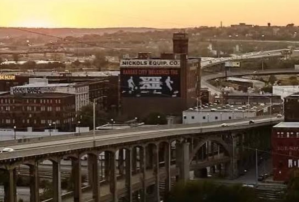
…for the next time you see one of those long BNSF freight trains chugging along the tracks. Whether you see one of those BNSF freight trains in Los Angeles. Or in New York City. Or in Dallas. Or in Chicago. The next time you see one of those BNSF freight trains, you can think about a town located along the Flint Hills Scenic Byway in Chase County, Kansas. You can think about Strong City. Population, 388.

Five years after the Kansas Territory was first organized… Two years prior to Kansas becoming our 34th U.S. State…Chase County, Kansas was born. That year? 1859.

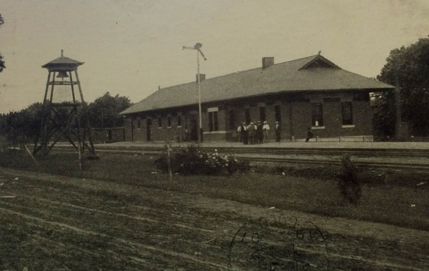
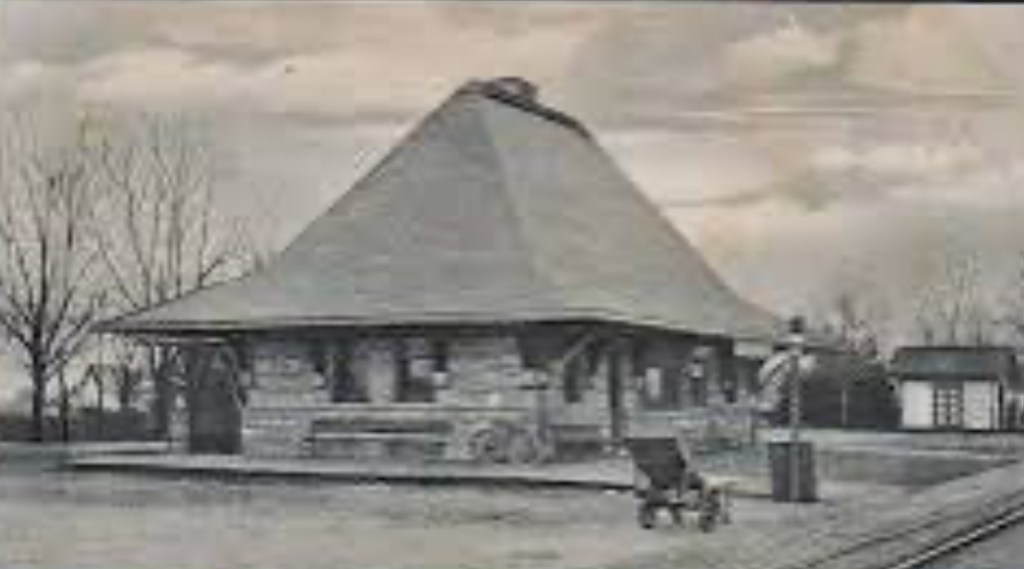
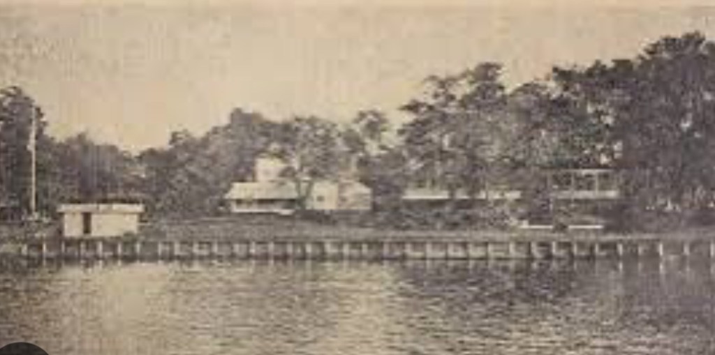
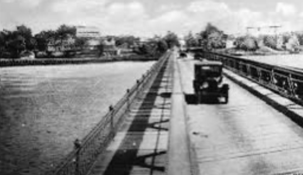
Twenty-two years after that – in 1881 – the railroad in the United States entered Chase County, Kansas. The Chase County town which was the benefactor of this rail extension in Kansas had been Cottonwood. 


And in Cottonwood, a new train station was built. That new train station – built in 1881 in Cottonwood – became, the Cottonwood Station. 

The very next year – in 1882 – the town of Cottonwood would change its name. Becoming, Strong. Later becoming, Strong City

Our Strong City name took hold much, much later. Sixty-three years later, to be precise. In 1945.

Strong City

Yet, let’s go back to the beginning of it all. To the very beginning of Strong City’s – then, Strong’s – imprint on U.S. rail. 

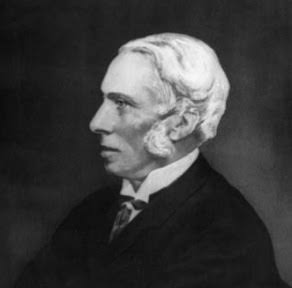
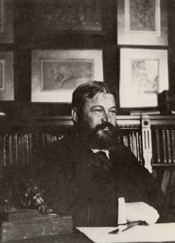
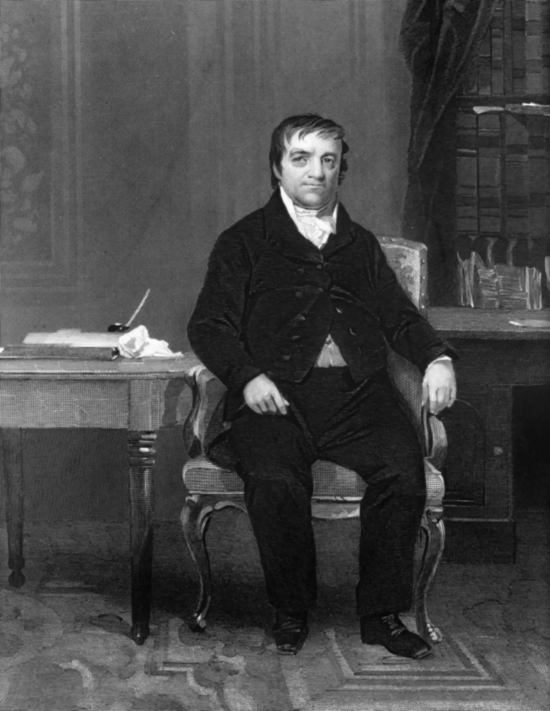
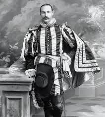
The beginning, which brings us to a New Englander. A New Englander, who was born in Vermont. A New Englander by the name of William Barlow Strong. W.B. Strong. As W.B. Strong is where our Strong City-BNSF connection begins. 

W.B. Strong. Our namesake for Strong. Our namesake for Strong City. W.B. Strong. W.B.Strong, the man on whom a petition had been set forth to change a Chase County town’s name. From Cottonwood to Strong.

When that railroad –  the Atchison, Topeka and Santa Fe Railway – was extended into Cottonwood in 1881, W.B. Strong served as president at Atchison, Topeka and Santa Fe Railway.


The year Cottonwood Station first opened- in 1881 – would be the same year W.B. Strong took over the reins at Atchison, Topeka and Santa Fe Railway. As president. Atchison, Topeka and Santa Fe Railway. ATSF, for short.

Expanding on from the opening of that Cottonwood Station in 1881, under W.B. Strong’s leadership, ATSF significantly grew its train routes. To cover 7,000 miles. 7,000 miles of Atchison, Topeka and Santa Fe Railway routes. Throughout the United States.

Headed by W.B. Strong, Atchison, Topeka and Santa Fe Railway went on to become part of what is today the largest railroad in the United States. ATSF’s growth spurt coincided with the opening of that Cottonwood Station. In our Chase County town that would go on to bear W.B. Strong’s name. In Cottonwood. Later becoming, Strong. Later becoming, Strong City. 

Strong City. The Chase County town named after our railroad executive, W.B. Strong.

Whenever we see a freight train, we no doubt will see the letters “BNSF” on those freight cars. And on those, once-steam, now diesel or electric, engines. BNSF is our modern-day evolution for Atchison, Topeka and Santa Fe Railway.

Atchison, Topeka and Santa Fe Railway went on to merge with Burlington Northern Railroad in 1995. Out of this merger, we had, Burlington Northern & Santa Fe Railway. 


Later becoming, simply, BNSF.


The prevalence of those BNSF freight trains we see throughout the United States…transporting goods from the West Coast to the East Coast. From the Midwest into Canada. From the Midwest into Mexico. The prevalence of those BNSF freight trains we see…we see those BNSF freight trains, arguably, as the modern day result of the expansion-oriented mindset which had been espoused by the man whose name is forever linked to our Chase County town. W.B. Strong. Our namesake, for Strong City. 

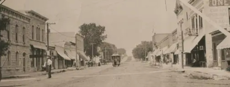
In the late 19th Century, then-Cottonwood, later becoming Strong and later still, becoming Strong City, had a population of, between, a few hundred to one thousand people. Strong City’s population today is just about where it had been in its earliest days. A few hundred people.

Just as our Strong City forefather – W.B. Strong – laid the late 19th Century “tracks” for a company which would go to become the largest rail company in the United States – with over 32,000 miles of track, across 28 U.S. States – Strong City would proceed to make a second notable contribution to the freight-by-rail system we now have. 

Beginning in the late-19th Century, Strong quarries supplied large quantities of the stone which had been used for U.S. railway expansion. While at the same time, Strong stonemasons handled a good deal of the stone-work which had been necessary in order for that that late-19th Century/early-20th Century rail expansion to take place. 


While Strong stonemasons performed according to their names – as stonemasons, handling stone-work for railroads – Strong stonemasons extended their contributions to the growth of late-19th Century/early-20th Century rail in the U.S. beyond their stone-work. In fact, Strong stonemasons went on to enter into numerous phases of late-19th Century/early-20th Century railroad construction. Far beyond stone-work.

The laying of track. Building the bridges on which track was laid. Building train stations. Roadhouses. 


Each being one such category of railroad construction that Strong stonemasons placed their signatures upon.

So…our Chase County town of 300-or-so residents, located a little less than a two hour’s drive west of Kansas City. Our Chase County town can be thought of whenever we do see one of those BNSF freight trains.

W.B. Strong. Strong. Later becoming, Strong City. Strong stonemasons. United States rail. BNSF. 

For me, it’s quite difficult, moreso, impossible, to see a freight train and to not think about those picturesque drives I’ve taken, oh so many, many times, along Highway 177 in Kansas. Onto Main Street. Along the Flint Hills National Scenic Byway. Into…Strong City.

Strong City. Our Chase County town of 300-or-so people which has left its not so-little-at-all “Strong City signature” – in more ways than one – on U.S.cargo, shipped by rail. 

Lee’s Summit…in the very beginning.


In 1865, at the conclusion of the Civil War, William B. Howard filed a plat to establish a new Missouri town. This new Missouri town would be located 25 miles to the southeast of Kansas City. The platting for Howard’s new town would become the Town of Strother.

Growth prospects for the Town of Strother, as well as planning for the economies of numerous towns which would emerge (or reemerge) in post-Civil War times, had been triggered by post-War Reconstruction. 

The founder of the Town of Strother – I.e.: Lee’s Summit – is William Bullitt Howard.

The name for the Town of Strother, paying homage to William Bullit Howard’s late wife, Maria Strother. 

Maria Strother died the same year William B. Howard filed his plat to establish the Town of Strother – 1865.

Land on which this new Missouri town would be erected totaled 70 acres. This 70-acre allotment which would go on to become Lee’s Summit was parceled out from the 800-plus acre Missouri plantation owned by William B. Howard.

Born and raised in Kentucky, William B. Howard moved to Jackson County, Missouri in the 1840’s. Coming from a wealthy family in the South, William B. Howard did not serve in the Civil War. As the War raged on, William B. Howard left Missouri. Returning to his native Kentucky. Preceding his later return to Missouri. Preceding the establishment of Lee’s Summit.

At War’s end, Howard did indeed return to his adopted Missouri. Returning to Missouri, while holding a belief that a pending rail connection of St. Louis to Kansas City would create opportunities in commerce. Opportunities which were sure to benefit William B. Howard. A large landowner. 

When the Civil War came to a close, recognizing the role rail was certain to play in a post-War economy – and in opportunities for growth in and around Kansas City – William B. Howard entered into negotiations with Missouri Pacific Railroad. Howard negotiated the construction of a new depot. A new depot which was to be built alongside Missouri Pacific Railroad tracks. Just south of Kansas City. On Howard’s land.

Missouri Pacific Railroad proceeded to build their new depot on Howard’s land in Strother.

Upon the incorporation of the Town of Strother in 1868, there was a name change for the town. From the Town of Strother. To Lee’s Summit.

Construction of a second Lee’s Summit depot – the all-brick Missouri Pacific Depot which, still, is located in downtown Lees’s Summit, to this day – was completed years later. In 1905. 

The current Missouri Pacific Depot replaced the older, original boxcar station which had been built in the Town of Strother by Missouri Pacific. That old Missouri Pacific boxcar station, and one famous old boxcar parked at that old station, played a humorous yet important role in the town’s name. 

The Missouri Pacific Depot which would be built on Howard’s land enabled passengers to travel from Lee’s Summit to St. Louis. That railway connection, having been completed two years after Howard filed his original plat for the Town of Strother in 1865. The Kansas City-to-St. Louis rail connection was completed in 1867. Two years after Howard filed his plat to establish the Town of Strother. One year prior to the incorporation of Lee’s Summit.

The name change from the Town of Strother to Lee’s Summit is attributed to William B. Howard learning of another Missouri town which had also been named “Strother.”

The “Lee” in Lee’s Summit.

Upon relocating to Missouri, from Kentucky, William B. Howard resided in Big Cedar. In Jackson County. Among Howard’s neighbors and friends in Big Cedar had been the Leas. Pleasant and Lucinda Lea. 

Pleasant Lea was the local doctor. And postmaster. The Lea family and the Howard family grew to become close friends. Sharing more than their adjacent Missouri addresses. They shared also, their southern pasts.

The Leas moved to Jackson County from Tennessee. The Howards moved to Jackson County from Kentucky. Each family had been a wealthy, transplanted southern family. Establishing new homes for themselves just outside of Kansas City. In Civil War times. 

Pleasant Lea died in 1862. Three years before William B. Howard filed his plat to establish his Town of Strother. Which had originally been named for his late wife.

The change in the town’s name from the Town of Strother to Lee’s Summit involved another close relationship of Howard’s. His neighbor and friend, Pleasant Lee. 

Pleasant Lea, the origin for our “Lee” in Lee’s Summit.

Pleasant Lea resided in Big Cedar, to the south of Kansas City, prior to the Howards’ arrival. Pleasant Lea. The local doctor. The local postmaster. Pleasant Lea, William B. Howard’s close friend. 

It’s Pleasant Lea, spelled L – E – A , so why is it Lee’s Summit, spelled L – E – E?

What should have been spelled out as “Lea’s Summit” – Lea – on a boxcar at that old Missouri Pacific Depot in the Town of Strother, was simply a misspelling. 

That boxcar should have had Lea’s Summit” painted on it. L – E – A. The “Lea” denoting the correct spelling for Pleasant Lea’s last name – Lea.

Rather, that boxcar had “Lee’s Summit” painted on it. A misspelling. And so, going forward, the “a” in Lea’s was dropped. Replaced with the “e.” To arrive at, Lee’s Summit.

The “Summit” in Lee’s Summit.

The definition of summit is, the highest point of a hill or mountain.

The “Summit” in Lee’s Summit was coined in recognition of Lee’s Summit being the highest point on the Missouri Pacific line which ran from St. Louis to Omaha, Nebraska.

Lee’s Summit. The name for which we find a wealthy landowner, originally from Kentucky. The railroad. A neighbor. And an elevation point. 

Asbury Park…architecture named for the Queen


Queen Anne style architecture in Asbury Park, New Jersey can be spoken of as late-19th Century Victorian-styled homes. Victorian homes boasting of seaside-inspired asymmetrical designs.

The building of Queen Anne-styled homes in Asbury Park enjoyed a 30-year run in popularity. Beginning in 1880.

Originally, home for a Queen Anne-style home, was England.

Americans speak English. The British speak English. Yet, in taking a Shakespeare course in college, I discovered that while Shakespeare did indeed write in English, Shakespeare’s English required a translation.

So, in order to translate Early Modern English, Professor Carey read Shakespeare while translating the Early Modern English to a context that I could follow.

Historically, sometimes that of old English origin isn’t exactly the same as it is upon arrival in the United States. Even when it is “the same.”

This can be said of architecture.

In one such case, English architecture which ended up coming to the United States – architecture known by the same name in Great Britain as it was in the States – followed that storyline.

Shakespearean English. American English. Queen Anne-style architecture in England. Queen Anne-style architecture in the United States. English-inspired Queen Anne architecture in Asbury Park. In each case, the labels match. Yet, the products…not exact matches.

Ocean Grove, Avon-by-the-Sea, Long Branch and Asbury Park. Each, a Jersey Shore seaside gem established long, long ago along the coast of Monmouth County.

Asbury Park…

In Asbury Park, a segment of the city’s architecture tastes of a Victorian flavor. These being homes built in Asbury Park near Deal Lake.

Following the pattern of Victorian homes which were then being built on the East Coast during the latter stages of the 18th Century, three floors were the standard in a Queen Anne home. Following that trend, three-floor Queen Anne homes would be built in Asbury Park.


Whereas Queen Anne homes being built on the West Coast at this time tended to have two floors.

In Asbury Park, the Queen had her say…

Beginning late in the 1800’s, and extending on through the early part of the 20th Century, a New World Queen Anne Revival in architecture was becoming quite popular on the Jersey Shore. And Asbury Park was incorporated, right around this time.

First developed as a residential resort in 1871, Asbury Park was incorporated three years later. Asbury Park’s beginning, occurring just as this architectural trend from England – a style, named for a Queen – took hold.

Queen Anne-style architecture was a popular choice in the United States from 1880 through 1910.

Queen Anne, an 18th Century English Queen. She, a Queen holding the throne from 1702 through 1714. Asbury Park adopted their own version of this trend in architecture which had been named for the queen.


Homes built in Asbury Park utilized a style found within the Queen Anne architectural movement. These designs, which found their way onto 19th Century Asbury Park blue prints, not being mirror images of those used for Queen Anne homes built in Great Britain.

Queen Anne homes of Great Britain were more closely aligned with the Arts and Crafts movement than were their Asbury Park sister homes.

Distinct brickwork. Corner towers. Wide porches. Asymmetrical fronts. Red-brick walls which were commonly offset by pale stone. White-painted woodwork. Bay windows. Characteristics found in a Queen Anne home built in Great Britain late in the 19th Century. And early in the 20th century.

In the midst of Great Britain’s Industrial Age, one British architect’s Queen Anne imprint was famously being cast upon the English landscape. He, an English architect whom many an American has heard of – Norman Shaw.


Born in Scotland, Norman Shaw is widely considered to be one of the very finest architects Great Britain has ever produced. Or, the world has produced, for that matter. 

Norman Shaw is responsible for a consortium of Queen Anne structures which, to this day, still proudly stand in Great Britain. Among Shaw’s 19th Century Queen Anne Revival contributions to Great Britain? Albert Hall Mansions.


Shaw’s Albert Hall Mansions was built in 1878. Four years after Asbury Park was established.

Queen Anne masterpieces designed by Shaw were famous for blending characteristics taken from Arts and Crafts homes. As well as from Tudor homes.

With regard to Asbury Park’s version of Queen Anne architecture, when one looks, one will see an inspiration drawn from this style. Inspired by, yet not an exact match.

Asbury Park’s Queen Anne-styled influence can best be seen when walking near Deal Lake. Seen in the turrets. Seen in the towers. Towers and turrets of a Queen Anne design. First thought up in England.

Several of the towers affixed to Asbury Park homes prominently stand three stories tall. Just as a comparable tower which had been added to a Queen Anne blue print in England by Shaw, so too, still stands.

Named for the Queen, made popular in England by one of the world’s most renowned architects, Asbury Park’s version of a Queen Anne home adopted distinct Asbury Park features.

For example…

In Asbury Park, the stateliness of a Queen Anne home often included a wrap-around porch. Also, we’ll see the bay windows in an Asbury Park Queen Anne home. Norman Shaw also liked bay windows. Yet in Asbury Park, the bay windows we’d see would have been below a cedar shingled-roof. Wood shingled-roofs were quite popular in Asbury Park Queen Anne homes.


Not so for a Queen Anne home designed by Norman Shaw in England.

Norman Shaw favored roofs owning a very steep pitch. A favorite of Shaw, his roofs were often finished with red tile. Not wood shingles. With Shaw roofs often married to handsome gables. And to decorative chimneys.

Whereas Shaw went with a deep pitch for his roofs, Queen Anne roofs in Asbury Park had uniquely irregular shapes. Less-reliant upon a steep pitch.

While cedar shingle roofs were commonly found in Asbury Park, such a roof might also have had terracotta tiles. Or metal cornices. Neither of which, Shaw would have used.

The facades…

Norman Shaw’s facades felt fortress-like. Stone-clad. Classic. Old English. Shaw’s facades, inspired by medieval times.

While in Asbury Park, the facade of a Queen Anne home took a different direction.

Asbury Park Queen Anne architecture is known for asymmetrical fronts. And in comparison to Shaw’s homes, for lighter color schemes.

An Asbury Park Queen Anne home would also have had more windows than a Queen Anne home built by Shaw. With lighter color schemes – as well as higher window counts – reflective of Asbury Park being an oceanside community.

Old English – much like Queen Anne architecture – was translated. And in so for each, exactness accompanied not, the translations.

The Texas longhorn: Colorful. Distinct. Expensive.


The origin of the name? Their distinct, pronounced long horns. Long horns which can exceed 8 feet in width. From tip to tip.

Bulls weigh between 1,500 to 2,000 pounds. Cows weigh less. On average, 1,000 pounds. 

The Texas longhorn.

Texas longhorn color is unique to the breed. Texas longhorn colors vary. And vary they do. Quite a bit. 

Just about four-out-of-ten Texas longhorns proudly wear their light red coat. The Texas longhorn coat might also be black. Or yellow. Or brown. Or white. Or brindle. The Texas longhorn coat could also be blue. Blue, that is, with a gray-ish tint.

At auction, the color category of the Texas longhorn have bestows a distinct identity.With rarity in color for the Texas longhorn correlating to a higher price fetched at auction. 

Facing near-extinction one hundred years ago, thinning during the 1960’s to a dangerously-low head count, while today the Texas longhorn is primarily found in Texas, the breed confidently grazes – no longer facing extinction – on ranches throughout the United States. A “trophy” on any ranch.

Long, long ago, the Texas longhorn was known as “Texas cattle.” Ancestors of “Texas cattle?” “Mexican cattle.”

Descendants of the Texas longhorn were first introduced to North America during the 1400’s. Finding their way here, thanks to Spanish explorers. The introduction of the Texas longhorn to our prairies dates back to the days of Christopher Columbus. To the days when Columbus led his expedition to the Americas.

With regard to the introduction of the Texas longhorn to North America, the Texas longhorn came ashore in Mexico. From Mexico, as Spanish explorers ventured north into what would go on to become Texas, the Texas longhorn accompanied Spaniards on their northern ventures. Hence, the introduction of “Mexican cattle” to a territory which would one day go on to become Texas.

Cattle brought to North America by Spaniards. “Mexican cattle” led north to Texas. “Mexican cattle” renamed “Texas cattle.” “Texas cattle” renamed “Texas longhorns.”

As more Spanish settlements in the Americas took hold, as the number of settlements established in the Americas by additional European countries grew, so too did grow cattle head count on the continent. Head count for the Texas longhorn increased.

Spaniards reached today’s Texas by the end of the 17th Century. With Spaniards arriving in Texas, along too, came their longhorns. 

The Texas longhorn footprint expanded. North into Texas. To the east, into Louisiana. 

As cattle head increased, inevitably, some head were bound to escape from captivity. And escape, some did.

Found among escaping Spanish cattle in Texas, our foundation for the history of the Texas longhorn in the United States begins.

Escaping longhorns…

The Texas Longhorn roamed Texas – roaming freely, upon their escape from captivity – through the final days of the 19th Century. At which time, the cattle industry changed Texas longhorn fate.

Late in the 19th Century, the Texas longhorn began to be rounded up en masse. Rounded up and loaded onto rail cars. To be shipped off. Shipped north, that is. To Kansas City slaughterhouses.

Ten-year totals for head of cattle shipped north to slaughterhouses during the last decades of the 1800’s exceeded 5,000,000 head. Over 5,000,000 head of cattle shipped north, per decade.

Those prairies the Texas longhorn escaped to were perfect for grazing. Upon the escape of the Texas longhorn from captivity, the Texas longhorn was not alone on the prairie. The longhorn had company.

The Texas longhorn escaped to what had been “bison country.” In “bison country” the Texas longhorn lived free as, as the bison’s neighbor. Bison and the Texas longhorn, alongside one another for centuries. 

That neighborly existence of bison and longhorn began in the 15th Century. When the longhorn was first brought to the western hemisphere. Brought from Europe. Aboard Spanish ships. 

In the 15th Century, longhorn count in North America had been low. North American settlement by Europeans – as well as the introduction of cattle to North America – was in its infancy.

Fast forward a few hundred years to the Texas longhorn’s prime. The last days of the 19th Century. 

As the 19th Century drew to a close, that “bison country” the Texas longhorn escaped to was subjected to an extermination. This was an extermination at the hands of the United States government.

In the late 1800’s, “bison country” was in the process of being cleared. Cleared of bison. Cleared by the government of the United States.

United States prairies cleared of bison. This, a concerted effort undertaken by the United States to rid the western corridor of the country of the primary food source of Native Americans. Native Americans, whom the United States government was intent on removing from their land, hunted bison. Eliminating the bison. Eliminating Native Americans. Opening up the west for United States expansion.

The Texas longhorn thrived in “bison country” when they arrived. The Texas longhorn thrived in “bison country” for hundreds of years. Thriving alongside bison.

The removal of the Texas longhorn’s competition for rich prairie grasses – this removal being the extermination of bison by the United States government – as the Civil War was coming to a close led to what would turn into the United States’ southwest becoming blanketed by cattle. 

Head count of cattle increased. Head count of the Texas longhorn increased. 

Prime years which encompassed the run for the Texas longhorn as a major contributor to the economy of Texas – and to bottom lines for Kansas City slaughterhouses – would be late in the 18th Century through the first two decades of the 20th Century. 

By the 1920’s, the United States southwest was undertaking a notable increase in private property ownership. Private property, that is, which would now be fenced off. 

The increase in private land ownership by individuals in Texas – as well as in the United States’ southwest – by the 1920’s substantially curtailed the Texas longhorn’s once unimpeded access to thousands of acres of rich grassland. The Texas longhorn’s food source – that open grassland – was significantly altered. 

Between 500,000 to 1,000,000 head of cattle were shipped by train from Texas to Kansas City annually during the latter days of the 19th Century. 

By the mid-1960’s there were fewer than 2,000 Texas longhorns in the United States. Total.

Once nearly wiped from existence entirely, today, Texas longhorn head count exceeds 300,000. 

The reemergence of the Texas longhorn in Texas, as well as on privately-owned ranches throughout the United States, firmly re-established.

Today, if you are looking to purchase one Texas longhorn, you can expect to write a check for between $2,000 to $5,000. At a minimum.

For breeds of the Texas longhorn, breeds with a horn width considered to be wide, tip-to-tip (T2T), the price paid for one head will increase. The wider the T2T, the higher the price for one Texas longhorn.

The color of a Texas longhorn also affects its price. 

The coat of the Texas longhorn sports an interesting array of desirable color coordinations. 

Three Texas longhorn coat categories have traditionally been acknowledged to be the most highly-sought after: 1) White Roan, 2) Brindle, and 3) Grulla.

The Texas longhorn with the White Roan coat also possesses a red-ish pigment. Influenced by a roan gene. The result? The Texas longhorn whose coat is blue-ish in color. 

The Texas longhorn with the Brindle coat? That Texas longhorn will own vertical black stripes.

The Texas longhorn with the Grulla coat? That Texas longhorn would be silver-ish in color. 

Should you decide to purchase one Texas longhorn, one whose genetic history can be documented to be of “championship pedigree,” that $2,000 to $5,000 check you’d write to buy one head would increase. Increase substantially. To a few hundred thousand dollars. For one head.

The top price paid for one Texas longhorn?  $700,000.

Little Silver


Located 47 miles to the south of New York City, bordering Red Bank, Fair Haven and Rumson, home to 12-acre Parker, Sickles Farm Park, with a population of a cat’s whisker over 6,000 residents, we find the Borough of Little Silver. An exclusive community majestically nestled alongside the Shrewsbury River. This Monmouth County borough speaks to boating and water sports enthusiasts.

The beginning for Little Silver was that of a quiet agricultural community. With fisheries adding to the borough’s landscape in its earliest days.

Little Silver’s history dates back to 1663. To a King’s Land Grant. A land grant from Great Britain by the King of England, King Charles II.

Two years after King Charles’ land grant, a Rhode Island Quaker by the name of Peter Parker settled with his family in what went on to become Little Silver. This, in 1665. 

Our borough’s name of “Little Silver.”

The origin for “Little Silver” came about when Peter Parker named his new settlement in Monmouth County after his father’s Portsmouth, Rhode estate. His father’s Portsmouth estate, Little Silver. 

With Parker’s arrival along the Shrewsbury, neighboring settlements forming around Parker’s Homestead affectionately referred to the area as Parkerville. As a tribute to Peter Parker. 


The Parker Homestead was built in 1720. Built on today what would be Rumson Road, alongside Parker’s Creek.

Parker family descendants resided at the original Homestead for over three-hundred years. The last Parker residing at the original Homestead was Julie Parker. 

The last surviving Parker Homesteader, Julie Parker passed away in 1995. Her death marking an end to 330 years of uninterrupted occupancy at the original Homestead by a member of the Parker family. 

From early settlement, to destination point.

During the 19th Century the emergence of steamboats added to Little Silver’s guest list. With Patten Line Steamboats handling maritime transportation to and from Little Silver.

This topic of steamboat travel and Little Silver connect us to one steamboat captain in particular. A steamboat captain to whom an epoch found within Little Silver’s past is correlated. A steamboat captain whose signature was scripted to Little Silver in the 19th Century.


A steamboat captain: the founding father of Little Silver Point.

In 1844 a steamboat captain by the name of John Borden arrived in Little Silver. Relocating to Little Silver from nearby Red Bank. With his arrival in Little Silver, John Borden proceeded to establish Little Silver Point. An unincorporated section of Little Silver. 

Prior to the establishment of Little Silver Point, this peninsula in Little Silver’s northeast corner had been not much more than farmland. And soggy saltwater marshes.

The arrival of John Borden in Little Silver marked the beginning of a transformation for the peninsula.

Little Silver Point changed. Taking on a new identity. One scripted by the construction of fancy hotels on the peninsula.

Those early hotels built in Little Silver Point would accommodate visitors coming to a new Little Silver Point. On steamboats. Little Silver’s farms and marshes, no longer defining fabric for the peninsula.

John Borden’s lot in life had always been his pioneering of steamboats. Steamboats let New Yorkers come to Little Silver Point. Little Silver Point became a sought-after resort. Guests arriving in Little Silver Point atop steamboat decks.

John Borden passed his steamboat acumen on to his son, Richard Borden. Cementing the Bordens in Little Silver history, Richard Borden went on to operate Silver Bay House in Little Silver.

Borden’s Silver Bay House became the place to go for New Yorkers who came to Little Silver on Patten Line steamboats. 

Patten Line’s path to Little Silver’s riverside hotels was the Shrewsbury River. The Patten Line connected Monmouth County to Battery Park from the end of the Civil War to the 1930’s. 

It was a sixty year-run for those Patten Line steamboats which started their voyages in Battery Park. Arriving in Monmouth County on the Shrewsbury River.

Accompanying 19th Century steamboat travel, the advent of passenger trains contributed to Little Silver’s accessibility.

Construction of The Little Silver Train Station occurred in 1875. Little Silver’s station was built by the New York and Long Branch Railroad.

The original station in Little Silver served passengers for fifteen years. From 1875 through 1890. 

The original station was replaced in 1890 by the structure which still stands along tracks in Little Silver to this day. At the intersection where Branch Avenue meets Sycamore Avenue. 

The one-hundred thirty-six year old station we find in Little Silver at 705 Branch Avenue in 2026 gets commuters to Newark’s Penn Station. And New York’s Penn Station. 

The Little River Train Station, with its sandstone exterior and its distinct slate roof, was the creation of a famed architect from Brookline, Massachusetts.


The Little River Train Station architectural design is attributable to Henry Hobson Richardson.

Henry Hobson Richardson’s contributions to the American architectural landscape include The Little Silver Train Station, Trinity Church and the Boston Public Library.

Up through 1923 Little Silver had been part of Shrewsbury Township. Little Silver became its own municipality through an act of the New Jersey legislature in March of 1923.

Little Silver’s history is intertwined with the Shrewsbury River. This connection of borough to waterway, foretelling still Little Silver of today.

In 2026, nearly 10% of all homes in Little Silver touch the banks of the Shrewsbury River. 

Four hundred years after King Charles’ land grant to this riverside settlement, the river remains an anchor for the settlement.

Long, long ago, the Shrewsbury River functioned as a maritime agent for those visiting Little Silver Point. Today, the Shrewsbury River can be characterized as a waterway pillar. A waterfront pillar upon which a stock of distinct Monmouth County real estate now proudly resides.

Rumson, New Jersey…in the very beginning.


The Borough of Rumson is a charming seven square mile bedroom community of New York City. With two of those seven square miles, consisting of water.

Rumson is home to a tad more than 7,000. Long, long before Rumson became Rumson, Rumson was Navarumsunk. Or, Narumsum. 

Today’s Rumson was once Navarumsunk. This, when territory including the 7 square miles which would one day become Rumson was purchased by English settlers. English settlers who migrated to the area from New England. And from Long Island. English sellers purchased Navarumsunk from the Lenape Indians.

Negotiations for the sale of Navarumsunk to English settlers began in 1663. Two years later, Governor Richard Nicholls confirmed the land purchase. By way of the Monmouth Patent. The year was 1665.

Through attrition, over time, due to, in a nutshell, shall we say, convenience, the longer Indian denomination of Navarumsunk was shortened. Shortened, to Rumson

The origin for the borough’s name – Rumson – is seen in naming assigned by Native Americans. Navarumsunk. Navarumsum. Rumson.

Today’s Rumson resulted from this 17th Century land purchase. A sprawling acquisition of land, this sale by the Lenape, certainly was. Land sold consisted of one tract of land nestled in between the Navesink River and the Shrewsbury River.

Extending from today’s Sea Bright, to the east. Flowing west, to tributaries emptying into the Shrewsbury River. Today’s Rumson. 

Held by the English, Navarumsunk became Ramson’s Neck.

Ramson’s Neck was never a township. Ramson’s Neck was never a settlement. Ramson’s Neck included what would go on to become Rumson. 

The catalyst for our 1665 land purchase which became Ramson’s Neck, a section of which, later becoming Rumson, was found across “the Pond” – English colonial expansion.

A land conveyance by royalty in Great Britain can be pointed to as the reason there was a Ramson’s Neck. This same royal land conveyance also led to the establishment of Monmouth County. This was a conveyance of land in what was then Dutch territory – New Netherlands.

England’s king at the time was King Charles II. Charles II granted land in New Netherlands to his brother, James. The Duke of York.

The king granted to the duke a tract of unsettled land inclusive of today’s Monmouth County.

At the time of conveyance – from king, to Duke – New Netherlands was controlled by the Dutch. The English had their sight on taking this Dutch region for themselves. This, a land mass extending from what today would be Connecticut, going due south, to today what would be Delaware.

Charles II granted this entire Mid-Atlantic region – from Connecticut to Delaware – to his brother. James. The Duke of York. 

Upon receiving this land from his brother, the King of England, Duke of York authorized Governor Richard Nicholls to commence settlements. Settlements in what was still the Dutch’s New Netherlands.

Underpinnings for English settlements in Dutch territory emanated from the Monmouth Patent. 


The Monmouth Patent, understood best, within our context, was the assumption by Governor Richard Nicholls of a responsibility. A responsibility bestowed upon Governor Nicholls by the Duke of York.

The responsibility? To attract one hundred families to settle in this Mid-Atlantic Dutch territory. By 1668. Three years to accomplish the settlement threshold. Which led to, the Nicholls grant. With Governor Nicholls providing land grants for settlement.


The Nicholls grant was for land in Monmouth County, Ocean County and Middlesex County. Monmouth County, in which our Borough of Rumson resides.

Establishment of one hundred new English settlements within three years, aligned with the Monmouth Patent, included a prerequisite. A condition.

A condition was attached by Great Britain to Governor Nicholls’ land grants.

In order for what today is Monmouth County, Ocean County and Middlesex County to not revert back to the Duke of York from Governor Nicholls one hundred settlements were to take hold within the three year allotment.

The very first English settlers to arrive by way of Nicholls grants went in Shrewsbury village.

The Nicholls grant bestowed upon settlers a broad discretion. This, to govern themselves.

The “carrot” of self governance. An enticement to settle. These settlers were called, Patentees. Aptly named, because at the very core, these settlements came through the Monmouth Patent.

The Monmouth Patent, the Nicholls grant and Patentees. Emanating from Great Britain. The colonial goal? To establish one hundred new English settlements over three years. In Dutch territory. The expansionist colonial mindset of the British Empire.

The Monmouth Patent hit a bump in the road. British expansion, struck, and removed from uninterrupted accord. 

In 1674, the Dutch recaptured their New Netherlands territory. Taken back. From the English. 

While Dutch governance of New Netherlands (once again) proved to be a short lived reign, previous English grants – the Nicholls grant, the Monmouth Patent – were nullified. Through the change in imperial governance. From Great Britain. To Holland. 

Nullified, technically. Yet English settlements were not as alterable as would be flying a Vlag van Nederland (flag of the Netherlands) rather than the Union Jack over settlements.

By 1675, the English wrestled control of the Mid-Atlantic from the Dutch. 

Seven years later, the duke’s goal for Governor Nicholls to establish one hundred settlements was far surpassed. By 1682, four settlements were established in Ramson’s Neck and in surrounding land. Encompassing thousands of acres of plantations. Precursors to numerous cuter boroughs and townships. One of which being, Rumson.

Through the Revolutionary War times, Ramson’s Neck – today’s Rumson, Fair Haven, Red Bank, Little Silver and Shrewsbury – were sections within Shrewsbury Township.

Rumson was part of Shrewsbury for the next hundred years. Rumson became an independent borough in 1907. Rumson’s birthday is March 15, 1907. 

St. Louis


“Buy on the fringe and wait. Buy land near a growing city! Buy real estate when other people want to sell. Hold what you buy!” – John Jacob Astor

When investing in real estate, ideally, one hopes to attain benefits such as: a) low acquisition cost, b) limited tenant problems, and, c) steady appreciation. A-B-C. One way to arrive at A-B-C is often overlooked.

A-B-C created America’s first multi-millionaire, John Jacob Astor. However, pursuing a real estate strategy comparable to the one America’s first multimillionaire utilized to become America’s first multimillionaire is not common.

For savvy investors, prioritizing the acquisition of nonperforming properties can be a good route to take. While this is not a process utilized by a majority of owner-occupying home buyers, owning the home you live in correlates to building net worth. For investors. For families.

Equity built up in homes (over time) makes up in excess of 75% of the total net worth for American families.

“Real Estate cannot be lost or stolen, nor can it be carried away. Purchased with common sense, paid for in full, and managed with reasonable care, it is about the safest investment in the world.” – Franklin D. Roosevelt


Identifying nonperforming properties available at great prices…

With regard paid to neighborhood stabilization and community development, land banks play an important role. They acquire – then convey – non-performing properties to those who can transition nonperforming properties into performing properties. Land bank properties can be acquired at prices which are less than market rate prices.

According to a report put forth by the Brookings Institute a few years ago, just about 15% of land in American cities is vacant. Vacant land can be categorized as nonperforming. In that vacant land does not generate property tax revenue. All the while, property taxes function as a vital source of revenue for cities.

Property taxes. A lack thereof?

Reduced property tax receipts impede the sustainability of any city. Reduced property tax receipts are one byproduct of nonperforming properties.

Nonperforming properties…let’s look at St. Louis.

Over the years, St. Louis took possession of in excess of 10,000 nonperforming properties. Residential homes. Vacant lots. Vacant buildings.

By conveying properties the city took possession of to developers, St. Louis alleviated having to operate as a de-facto property manager. Snow removal. Mowing lawns. Boarding up buildings. Tasks transferred in St. Louis to developers.

How so?

Not the conventional way. Neither St. Louis nor land banks use Realtors to sell properties. So let’s look at how St. Louis conveys properties.

Land Reutilization Authority…

The origin for St. Louis’s Land Reutilization Authority – LRA – is found in Title 1 of the Housing and Community Development Act of 1974. In the beginning, funding for the Land Reutilization Authority came through HUD.


The process in St. Louis…

To acquire a Land Reutilization Authority property, buyers complete an Offer To Purchase Form. Buyers submits Offer To Purchase Forms to the LRA, along with two most recent pay stubs, the prior year’s W2 and tax return and the buyer’s most recent bank statement. Buyers also discloses their funding source. A bank. mortgage company. Cash on hand. A Planning Sheet is attached to each buyer’s Offer To Purchase Form.

The Planning Sheet is an overview. The Planning Sheet provides details pertaining to the buyer’s vision for how they plan to improve the property.

The conveyance of city-owned properties and land banks properties happens at the local level. Procedures vary. City by city. Town by town.

At the federal level, an important “tool” used to facilitate the conveyance of properties through land banks became available in 2008.

Resulting from the Financial Crisis, Congress passed the Housing and Economic Recovery Act of 2008. The Housing and Economic Recovery Act appropriated $4 billion to address abandoned and foreclosed properties.

The Housing And Economic Recovery Act of 2008 later became the Neighborhood Stabilization Program. Commonly known as NSP.

One year after the NSP went into effect, Congress appropriated an additional $2 billion to address vacant and abandoned properties. Through the NSP.

The NSP provided the framework – and the funding mechanism – cities relied upon to create programs designed to combat problems arising from increasing numbers of nonperforming properties. A problem amplified by the Financial Crisis.


One approach used in St. Louis to lessen neighborhood blight was the Dollar House Program. To provide the Dollar House Program with inventory, the LRA placed properties in the Program which were owned by the LRA for at least five years.

The Dollar House Program provided owner-occupant applicants with an opportunity to inspect LRA homes. Upon completing inspections, buyers then established rehab budgets. After which, buyers were able to submit their applications to the LRA.

Buyer applications underwent board review. Should a buyer have been deemed to have met Program qualifications, with board approval, within 120 days buyers were expected to, a) stabilize the home, b) improve the facade, and c) follow building codes.

Renovation of Dollar House Program homes needed to be completed within 18 months. Furthermore, the buyer of the LRA home was required to live in their home for at least three years. Once they completed the rehab.

The LRA held a quitclaim deed to properties. Enabling the LRA to regain possession of properties should requirements established by the LRA not be met by buyers. The LRA was able to extend timelines for rehabs which took longer than 18 months to complete.

Buying a distressed home in St. Louis? Buying vacant land in St. Louis? Buying a rundown apartment building in St. Louis?

Some perspective…

Long, long ago, John Jacob Astor saw something he liked in an overlooked, sneered-upon, not-too-desirable piece of land. That then nonperforming piece of land that John Jacob Astor liked – then purchased – proved to be a decision which anchored his trajectory towards becoming America’s first multi-millionaire. This was a piece of land all know quite well.

Where was this land located?


Beginning in 1799, John Jacob Astor began to acquire vast amounts of land in New York City. Astor went on to become New York’s biggest landlord. Astor owned land in what today we know to be Times Square. And the East Village.

John Jacob Astor’s real estate was the backbone to his wealth.

When John Jacob Astor began buying Manhattan real estate, the population of New York City was 60,000. Fifty years later, New York City’s population exceeded 500,000.

“Buy on the fringe and wait. Buy land near a growing city! Buy real estate when other people want to sell. Hold what you buy!” – John Jacob Astor

The Navesink and Red Bank


Fine arts and galleries. World class gourmet. Performing arts. The International Beer, Wine and Food Festival. The Guinness Oyster Festival. Red Bank.

And on the north side of this charming Monmouth County town, we find the Navesink River. Eight miles in length, the Navesink is the result of a confluence. This confluence being, the Swimming River and several smaller streams. One of the tributaries of the Navesink River is Shrewsbury River.

The Navesink River and Red Bank. We’ll revisit their longstanding relationship after a trek through Red Bank history. This relationship between a river and a settlement is tantamount to how Red Bank came to be.

The borough of Red Bank derives its name from red soil discovered on banks of the Navesink. Red banks. Red Bank.

A riverside town of just about 13,000 residents, Red Bank’s history was written through receipts received for benefits attributed to the river which touched that settlement’s red banks.

Our Red Bank story goes back to the 17th Century. To long before Red Bank became a town. To long before Red Bank became a borough.

Red Bank as a borough…

Red Bank became a borough in 1908. Created through an act of the New Jersey legislature.

Red Bank as a town…

Red Bank’s history as a town predates its formation as a borough. By thirty-eight years. In 1860 the town of Red Bank was formed. Formed from parts of Shrewsbury Township.

A land sale, a deed, a river and red banks. A land sale consisting of three acres which extended to the “red bank” of the Navesink River established boundaries for a settlement.

A settlement which became a town. A town which became a borough. Red Bank.

Then too, this three acre land purchase in 1736 constituted the naming of Red Bank. “Three acres extending to the red bank of the Navesink River.”

A land purchase. A deed description. And red banks along the Navesink.

Our Red Bank beginning as a trading post…

Red Bank became a trading post ten years after the town of Red Bank had been formed in 1860. In 1870 Red Bank became a trading post.

Red Bank during the 17th Century…

Two hundred years prior to Red Bank’s incorporation as a town, in the 17th Century, European settlers were drawn to this location nearby two rivers – the Navesink and the Shrewsbury.

English and Dutch settlers established trade relationships with Native Americans along these red banks. Native Americans who themselves found favor setting up camp along the Navesink.

The Lenapehoking were Native American tribes who lived in Lenape territory on the Navesink. Lenape territory included this area along the Navesink. As well as land located in what today is New York City, eastern Pennsylvania and northern Delaware. Land along the Navesink which was hunted and fished by Lenape was Navarumsunk.

As English and Dutch arrived in this settlement, Lenape found their new European neighbors to be capable trading partners.

Aside from their ability to set up trade networks with Native Americans, English settlers brought with them familiarity with an industry which had been a “national champion” in Great Britain. Shipbuilding.

In the earliest days of Red Bank, shipbuilding was formative to the local economy. A shipbuilding industry pioneered by English settlers took hold. Developing as the result of a natural circumstance: this was a settlement alongside a navigable waterway.

Through their ability to navigate the Navesink, English shipbuilders benefitted from a fast-growing economy in Manhattan.

As Manhattan’s economy developed around textiles, the Navesink became a convenient channel through which ships coming from Red Bank could reach Manhattan. A trade route, facilitating the transportation of Manhattan textiles.

Come the early part of the 19th Century, as the economy in this region matured, Red Bank shipbuilders found a new beneficiary: those who traveled from Red Bank to Manhattan.

Early on, textiles, tanning and furs produced in Manhattan served as “passengers” onboard ships built in Red Bank. The movement of textiles. Along the Navesink.

During the 19th century, as the populations of New Jersey and New York City grew, as the economies of New Jersey and New York City grew, Red Bank shipbuilders adapted to the changing economy. Transitioning from building ships exclusively to serve the textile industry to building ships to serve the textile industry and commuters. Commuters being, passengers traveling from Red Bank to Manhattan.

One hundred years after that deed recording which noted “three acres extending to the red banks of the Navesink River,” steamboats enter our Red Bank story.

In 1809, regularly scheduled steamboat service going from Red Bank to Manhattan was available.

By the mid-1800’s, traveling to New York City from Red Bank by steamboat became a mainstay. Steamboats could be seen chugging along the Navesink.

Steamboat travel on the Navesink enjoyed a one hundred year run. The very last steamboat set sail from Red Bank in 1931.

Today, the Navesink sits as a beautiful piece within the “Red Bank collection.”

Yesterday, the Navesink sat as the mechanism on which Red Bank’s development was based.

Red Bank and the Navesink. Partners today. Partners yesteryear. Partners for over 400 years.

Kansas City


Each year, on the day after Thanksgiving, a crowd of 200,000 or so Kansas Citians partake in a Paris of the Plains Christmas tradition – The Plaza Lighting Ceremony. 

Kansas City’s Country Club Plaza. Named for Kansas City’s Country Club District. The Plaza. A 14-block historic shopping and entertainment district located on the southern end of Kansas City, Missouri. On the northern end of Ward Parkway.

The Plaza…with looks accentuated by fountains. By carriage rides. By statues. By sculptures. By its Spanish architecture. And at Christmastime, The Plaza takes on additional charm.

From an architectural standpoint, The Plaza’s design could be categorized as, Spanish Colonial Revival. Or, as Moorish Revival. 


Stamped upon The Plaza is a signature which speaks to Spanish architecture. The Christmas season begins in Kansas City each year in The Plaza with the illumination of this Spanish architecture. The lighting of Kansas City’s “Sevilla.” A Christmas tradition in KC, dating back to 1925. 

Although, in 1925, the “Plaza lighting” would not have been recognized as an occurrence on which a 100-year tradition would (or even could) be based.

The Plaza Lighting Ceremony. 200,000 jewel-toned lights which adorn streets on The Plaza at Christmas.

One of those Plaza buildings with Christmas lights is The Mill Creek Building. On Mill Creek Parkway.

And it is this Mill Creek Building which provides us with our story for the tradition of The Plaza lighting.

Kansas City’s Mill Creek building was the very first building ever constructed on The Plaza. 

Built in 1923, at the time of its construction, The Mill Creek Building was not known as The Mill Creek Building. No, when The Mill Creek Building was built, The Mill Creek Building was the Suydam Building.

The look for the Suydam Building was introduced to Kansas City by an architect from New York. Edward Buehler Delk. 

Edward Buehler Delk arrived in Kansas City five years before the first “Plaza lighting” took place. Delk arrived in Kansas City in 1920. Coming to Kansas City to work for a real estate developer – J.C. Nichols. 

Implementation of the style used by Edward Buehler Delk to plan out The Plaza for J. C. Nichols was attributed to trips Delk took to Spain, to Mexico and to South America. Delk absorbed architectural styles he liked in each locale, then conveyed those styles to Nichols. To be used for Nichols’ Plaza.

The look of The Plaza – and of the Suydam Building – is a look more likely to be found in southern California than in the Midwest.


Edward Buehler Delk – he whose architectural vision fostered the Suydam Building, as well as The Plaza – favored styles he took in on his trips to Spain, Mexico and South America. Styles which can be categorized as Spanish Colonial Revival. Or, Moorish Revival.

In later years, Edward Buehler Delk went on to design Kansas City buildings for Frank Lloyd Wright.

Going back to The Mill Creek Building…

Kansas City’s Mill Creek Building – The Plaza’s first building – holds a special place in Plaza lighting history. As The Mill Creek Building – the Suydam Building in 1925 – is where our tradition of “the lighting” began.

The very first “Plaza lighting” was unintentional happenstance. No grandiose planning. This which spawned a one hundred year tradition in Kansas City arose from quite a humble beginning.

In 1925 it was a maintenance worker, a maintenance worker employed by J.C. Nichols’ company – this maintenance worker, Charles Pitrat – who hung one, single strand of Christmas lights on the Suydam Building.

Hundreds of thousands partake in Kansas City’s Christmastime tradition on The Plaza. A tradition started by a maintenance worker. A maintenance worker who hung one single strand of Christmas lights on one building. The first building built in The Plaza. Designed by an architect on whose influence The Plaza is based. 

The Suydam Building. Now, the Mill Creek Building. 4634 – 4644 Mill Creek Parkway. Kansas City, Missouri. The Plaza’s first building. The first Plaza lighting.

Delk designed the building. Nichols built The Plaza. Lest we not forget when visiting The Plaza this time of year that it was a maintenance worker who hung that first stand of lights.

The prominent architect. The iconic Kansas City developer. And the maintenance worker. Our forefather for the lighting of The Plaza would be our maintenance worker, Charles Pitrat.

Kansas City


As a city, Kansas City trails only Paris with regard to each’s fountains count. The City of Fountains, as Kansas City is lovingly known to be, has over 200 fountains.

Some of those beautiful fountains in KC can be found near Kansas City’s majestic Union Station. From Union Station, take The Link over Grand Boulevard, and you arrive in the very heart of Crown Center.

At Christmastime, the beauty we find in Crown Center’s collection of fountains is accentuated by a special, special scene. Christmastime skaters.

For over fifty years Crown Center has been home to Kansas City’s original ice skating rink, Crown Center Ice Terrace. A staple for all who enjoy a Paris of the Plains Christmas.

Crown Center…

One of Kansas City’s true crown jewels would indeed be Crown Center. Another of Kansas City’s crown jewels would be the iconic corporation to which the fortunes of Crown Center Ice Terrace – as well as Crown Center itself – are owed. Hallmark. 

Each of our two Kansas City treasures – Crown Center and Hallmark – find their histories’ foundations in J.C. Hall. 

J.C. Hall…

As Kansas City continues to redevelop its downtown into one of the very finest downtowns in all of America, the wave of downtown redevelopment we see in Kansas City today also adopts into the club of downtown redevelopment leaders our forefather to Crown Center and to Hallmark, J.C. Hall.

While the focus of this article is not “redevelopment,” today’s Crown Center is very much emblematic of what can happen for a city when a corporate leader – in this case, J.C. Hall – opts to remain within a city’s downtown. Rather than follow (at that time) a trend of abandoning one’s center city roots by relocating to the suburbs.

The very beginning for Kansas City’s Crown Center goes back to a late 1960’s redevelopment plan. A redevelopment plan anchored through J.C Hall’s Crown Center businesses. A redevelopment plan which also received contributions from another iconic Kansas Citian, Walt Disney.

J.C. Hall. The one time door-to-door Avon salesman from Norfolk, Nebraska. Our Crown Center forefather.

J.C. Hall’s career evolved. From selling makeup, door-to-door. To selling postcards. And it was those postcards that J.C. Hall sold early on in his career that would bring J.C. Hall from his Cornhusker youth to Kansas City. And to forefather of Crown Center.

Yet, before we arrive at the company for which J.C. Hall’s “American signature” is forever most commonly linked, a prior step in his Kansas City business sequence

From postcards. To store. From store, to a grand department store. A grand department store in Crown Center.

Halls Department Store…

J.C. Hall began his career in Kansas City by selling his postcards. Later, adding greeting cards to his product offering. In time, J.C. Hall would go on to open that first store in Kansas City. The store from which he could sell his postcards. And his greeting cards too. This store that J.C. Hall opened in Kansas City would go on to become Halls Department Store.

Halls Department Store started out as a specialty store. With J.C. Halls offering much more of a retail collection than simply postcards and greeting cards. Yet those postcards and those greeting cards would certainly prove to be stalwarts to a J.C. Hall Crown Center icon. An icon that would go on to become a global brand. Hallmark.


At its origin, Halls Department Store stocked expensive, high-quality items. Favorites for upper echelon Kansas City patrons. In time, Halls Department Store had themselves a prime Country Club Plaza storefront.

Halls Department Store arrived in The Plaza in 1965. Later migrating from The Plaza to the hub of J.C.Hall’s enterprises. To where we find Halls Department Store today. Crown Center. 

Shoppers who visit Halls Department Store – Halls Department Store is owned by Hallmark – are heading over to Grand Boulevard. Halls Department Store. Grand Boulevard. Level 3. In Crown Center.

Crown Center, which also houses the headquarters for the centerpiece to J.C. Hall’s collection. That centerpiece, the “Crown Center nucleus” which benefitted from the experience J.C. Hall attained early on by selling his postcards? And his greeting cards? That centerpiece, is Hallmark.

J.C. Halls founded Hallmark Cards in 1910. 

Hallmark Cards has the same origin as does that of its founder, J.C. Hall. Greeting cards. Postcards.

Hallmark did not start out as Hallmark. Hallmark did not start out in Kansas City.

Hallmark Cards began in 1907 in Norfolk, Nebraska. Originally, as Norfolk Postcard Company.

The iconic Hallmark label was introduced as a stand-alone Norfolk Postcard Company brand eighteen years after J.C. Halls founded his Norfolk Postcard Company in Nebraska. Use of the Hallmark name began in 1928. 

In 1954, the original Norfolk Postcard Company – the company whose origin was the sale of those postcards in Nebraska by J.C.Hall – changed its company name. From its name at that time – Hall Brothers – to Hallmark. 

With Hallmark’s headquarters in Crown Center, with Halls Department Store in Crown Center, with J.C. Hall opting to keep his company in center city Kansas City rather than relocate to the suburbs, the underpinnings for Crown Center’s late-‘60’s redevelopment had been established. Redevelopment for Crown Center officially began in 1968. 

The beginning phase for the redevelopment of Crown Center involved construction of underground parking. As well as the central square. The central square in Crown Center, which is where we find our skaters.

Through redevelopment, Crown Center went on to become a truly unique mixed-use district. Offices. Retail. Theatres. Hotels… Crown Center opened to the public in 1971. Three years after redevelopment commenced.


Today, Crown Center encompasses 85 acres in Kansas City. Union Station. Our National World War I Museum and Memorial. Halls Department Store. Hallmark. Each, located in Crown Center.

Yet, at Christmastime, for so many, the Crown Center experience is best brought home by the ice skating. Ice skating made possible, that is, because one American corporate chief in Kansas City chose benefits bestowed upon his companies through redevelopment. Over a move out of Kansas City, to the suburbs.


So those happy skaters in Kansas City can thank a former door-to-door Avon salesman from Nebraska for their ice time fun.

They can thank J.C. Hall. Forefather of Crown Center.