The story of a Missouri town, a blacksmith, mountains which are not there and rivers which are not blue.


Within the Kansas City Metropolitan Area, to the southeast Kansas City – a 20-minute drive from Kansas City’s Central Business District – 10 miles outside of Independence, with a land area totaling 10 square miles, bisected by Blue Parkway, we find Raytown.

The origin of Raytown goes back to how significant the Santa Fe Trail was to the opening up of the West to American settlement. 

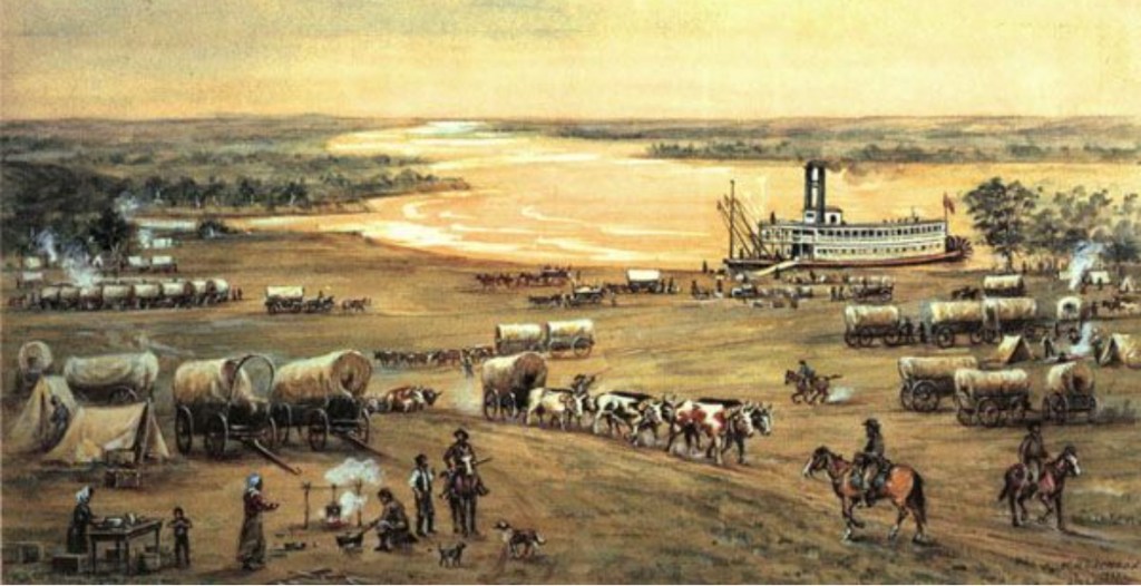
In the 1820’s, Raytown – at that time, a settlement known as Blue Ridge –  was a trading post. Established as a stopover along the Santa Fe Trail. 

Frontiersmen heading west rested up at this Blue Ridge settlement. Settlers purchased supplies they needed for their long trek west at Blue Ridge. They repaired their wagons. Settlers purchased flour, bacon and coffee at Blue Ridge. Settlers bought shoes for their horses at Blue Ridge. They visited the local Blue Ridge blacksmith. That local Blue Ridge blacksmith, coming to play a most significant role in Raytown’s history.

Attributed to how Blue Ridge has been written into the annals of our American story is the role Blue Ridge took on along the Santa Fe Trail. 

Early in the 19th Century, Blue Ridge served as a “refueling depot” for those who confronted the rigors of the Plains as they pursued adventure.

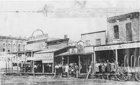
Blue Ridge was a busy post along the Santa Fe. Iron workers, wagon makers and blacksmiths flocked to Blue Ridge. Tradesmen. Tradesmen attracted to opportunities found in Blue Ridge emanating from the ever-growing number of wagon trains traveling the Santa Fe Trail. 

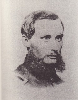
This Blue Ridge settlement came to be named for one such tradesman. A tradesman who came from the East. Arriving at Blue Ridge to partake in business opportunities created by Santa Fe Trail traffic. This tradesman was William Ray.

William Ray left his native Ohio, opting to make a new home for himself at Blue Ridge. William Ray built a new life for himself in Missouri. At this settlement along the Santa Fe Trail which would one day be named for him.

William Ray was a tradesman. William Ray was a blacksmith. As a blacksmith along the Santa Fe Trail, the shop William Ray established for himself was located at today what would be the corner of Raytown Road and 63rd Street. In the heart of Raytown.

This settlement of Blue Ridge would later come to be known as Ray’s Town. Ray’s Town…named for our Blue Ridge blacksmith from Ohio, William Ray.

William Ray was born in Butler County, Ohio in 1808. William Ray arrived in Missouri in 1848. Purchasing seven acres of land where today 63rd Street meets Raytown Road. In Raytown.

That acreage acquired by William Ray along the Santa Fe Trail was located at a junction where several trade routes met.

With his blacksmith shop – and his seven acres -situated at the heart of those Blue Ridge trade routes, William Ray’s address positioned him at the nucleus of where locals were clamoring for better roads to be built in Blue Ridge. The construction of new and improved roads – I.e.: local trade routes – which would connect Blue Ridge to the local, larger nearby markets of Independence and Kansas City.

William Ray’s blacksmith shop was located where those new roads would emanate from. Through William Ray’s geographical relevance, Blue Ridge locals started referring to Blue Ridge as “Ray’s Town.” Because planned growth for Blue Ridge involved the building of new roads which were to have beginning points at what today is the intersection of 63rd Street and Raytown Road. William Ray’s seven acres. William Ray’s blacksmith shop.

Within the American story there is an inescapability one encounters in the forever-association between the Santa Fe Trail and Blue Ridge. I.e.: Ray’s Town. I.e.: Raytown. 

In Raytown today, the path Blue Ridge Boulevard follows is the path of the original Santa Fe Trail. Yet there is no “blue ridge” in Raytown. There never was a blue ridge in Raytown.

The Blue Ridge Mountains…

Blue Ridge Parkway in Raytown was named after a mountain range – the Blue Ridge Mountains. 

Frontiersmen arriving at what would be, first, Blue Ridge, then later, Ray’s Town, then later, Raytown were taken back by how the wooded ridges they encountered in Missouri reminded them of the high wooded ridges familiar to them in the Blue Ridge Mountains. A mountain range located where their expedition west – to Missouri – began.

William Ray’s contribution to Raytown proved to be long lasting. Although William Ray’s residence in Raytown was nothing of the sort.

William Ray resided in Blue Ridge for only five years. Leaving Blue Ridge in 1853.

The story of William Ray leaving Blue Ridge – as well as the story of William Ray arriving in Blue Ridge – are each interwoven with famous American trails heading west.

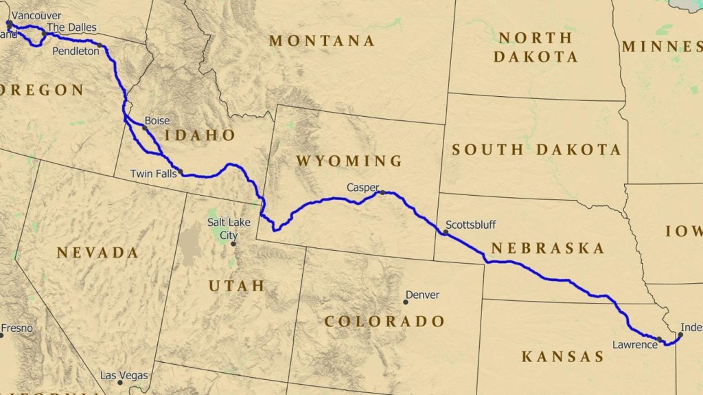
William Ray left Blue Ridge for Oregon in 1853. To live near his children. William Ray’s children lived in Oregon.

The beginning point for the Oregon Trail is found in Missouri. In Independence, Missouri.

The beginning point for the Oregon Trail – the trail which took William Ray’s children west, from Missouri to Oregon – is located ten miles from where William Ray had his blacksmith shop. At the corner of today what would be 63rd Street and Raytown Road. In Raytown.

The Navesink and Red Bank


Fine arts and galleries. World class gourmet. Performing arts. The International Beer, Wine and Food Festival. The Guinness Oyster Festival. Red Bank.

And on the north side of this charming Monmouth County town, we find the Navesink River. Eight miles in length, the Navesink is the result of a confluence. This confluence being, the Swimming River and several smaller streams. One of the tributaries of the Navesink River is Shrewsbury River.

The Navesink River and Red Bank. We’ll revisit their longstanding relationship after a trek through Red Bank history. This relationship between a river and a settlement is tantamount to how Red Bank came to be.

The borough of Red Bank derives its name from red soil discovered on banks of the Navesink. Red banks. Red Bank.

A riverside town of just about 13,000 residents, Red Bank’s history was written through receipts received for benefits attributed to the river which touched that settlement’s red banks.

Our Red Bank story goes back to the 17th Century. To long before Red Bank became a town. To long before Red Bank became a borough.

Red Bank as a borough…

Red Bank became a borough in 1908. Created through an act of the New Jersey legislature.

Red Bank as a town…

Red Bank’s history as a town predates its formation as a borough. By thirty-eight years. In 1860 the town of Red Bank was formed. Formed from parts of Shrewsbury Township.

A land sale, a deed, a river and red banks. A land sale consisting of three acres which extended to the “red bank” of the Navesink River established boundaries for a settlement.

A settlement which became a town. A town which became a borough. Red Bank.

Then too, this three acre land purchase in 1736 constituted the naming of Red Bank. “Three acres extending to the red bank of the Navesink River.”

A land purchase. A deed description. And red banks along the Navesink.

Our Red Bank beginning as a trading post…

Red Bank became a trading post ten years after the town of Red Bank had been formed in 1860. In 1870 Red Bank became a trading post.

Red Bank during the 17th Century…

Two hundred years prior to Red Bank’s incorporation as a town, in the 17th Century, European settlers were drawn to this location nearby two rivers – the Navesink and the Shrewsbury.

English and Dutch settlers established trade relationships with Native Americans along these red banks. Native Americans who themselves found favor setting up camp along the Navesink.

The Lenapehoking were Native American tribes who lived in Lenape territory on the Navesink. Lenape territory included this area along the Navesink. As well as land located in what today is New York City, eastern Pennsylvania and northern Delaware. Land along the Navesink which was hunted and fished by Lenape was Navarumsunk.

As English and Dutch arrived in this settlement, Lenape found their new European neighbors to be capable trading partners.

Aside from their ability to set up trade networks with Native Americans, English settlers brought with them familiarity with an industry which had been a “national champion” in Great Britain. Shipbuilding.

In the earliest days of Red Bank, shipbuilding was formative to the local economy. A shipbuilding industry pioneered by English settlers took hold. Developing as the result of a natural circumstance: this was a settlement alongside a navigable waterway.

Through their ability to navigate the Navesink, English shipbuilders benefitted from a fast-growing economy in Manhattan.

As Manhattan’s economy developed around textiles, the Navesink became a convenient channel through which ships coming from Red Bank could reach Manhattan. A trade route, facilitating the transportation of Manhattan textiles.

Come the early part of the 19th Century, as the economy in this region matured, Red Bank shipbuilders found a new beneficiary: those who traveled from Red Bank to Manhattan.

Early on, textiles, tanning and furs produced in Manhattan served as “passengers” onboard ships built in Red Bank. The movement of textiles. Along the Navesink.

During the 19th century, as the populations of New Jersey and New York City grew, as the economies of New Jersey and New York City grew, Red Bank shipbuilders adapted to the changing economy. Transitioning from building ships exclusively to serve the textile industry to building ships to serve the textile industry and commuters. Commuters being, passengers traveling from Red Bank to Manhattan.

One hundred years after that deed recording which noted “three acres extending to the red banks of the Navesink River,” steamboats enter our Red Bank story.

In 1809, regularly scheduled steamboat service going from Red Bank to Manhattan was available.

By the mid-1800’s, traveling to New York City from Red Bank by steamboat became a mainstay. Steamboats could be seen chugging along the Navesink.

Steamboat travel on the Navesink enjoyed a one hundred year run. The very last steamboat set sail from Red Bank in 1931.

Today, the Navesink sits as a beautiful piece within the “Red Bank collection.”

Yesterday, the Navesink sat as the mechanism on which Red Bank’s development was based.

Red Bank and the Navesink. Partners today. Partners yesteryear. Partners for over 400 years.

UCONN, and how the Huskies’ school came to be


In the year 1822, a boy by the name of Charles Storrs had been born into a world of Mansfield, Connecticut agriculture. The Storrs family…a family of Mansfield farmers.

While Charles Storrs’ 19th Century life found its origin in agriculture, Charles Storrs ventured out. Beyond his family’s humble Mansfield farm.

Charles Storrs migrated from an agricultural world, into Connecticut mercantilism. Going on to sell silk. For a Hartford manufacturer.

While Charles Storrs started out on a family farm in Mansfield, he attained his wealth by way of successes found in Connecticut mercantilism.

And, to the benefit of Charles Storrs’ home state of Connecticut, Charles Storrs turned back from his mercantile successes. Turning back to where it all began in Mansfield for Charles Storrs. Turning back, to agriculture.


The success of Charles Storrs…

In 1854, Charles Storrs ascended from silk salesman, to entrepreneur. By partnering with his older brother Augustus Storrs to establish Storrs Brothers. 

Charles Storrs headed the company he founded, the company which bore his name, from the company’s inception in 1854, on through 1879.

In 1880 Charles and Augustus Storrs donated 170 acres – along with several buildings – to the State of Connecticut. This land that Charles and Augustus Storrs granted to Connecticut was conveyed with a condition. The condition being, for Storrs’ farmland to become the ground on which a Connecticut agricultural school would be established. A college. An agricultural college.

These 170 Mansfield acres went on to become a Connecticut village. Storrs, Connecticut.

The agricultural school intentioned through the Storrs’ land conveyance went on to become a college – Storrs Agricultural College. Charles and Augustus Storrs, being the College’s founders.

Storrs Agricultural College evolved into the University of Connecticut. I.e.: UCONN.

One of those old buildings which had been given by the Storrs Brothers to the State of Connecticut went on to become the very first Storrs Agricultural College campus building – Edwin Whitney Hall. Which today, on UCONN’s campus, is the Edwin Whitney Residence and Dining Hall.

Today, the village of Storrs, Connecticut remains anchored in academia. The village’s stalwarts being UCONN. As well as the Connecticut Repository Theatre.

UCONN’s address? 110 Storrs Road, Storrs, Connecticut.

Wichita, Kansas


During the latter part of the 19th Century, at the Kansas end of the Texas-to-Kansas Chisholm Trail, an unruly establishment arose from the dusty streets of this frontier town.

This frontier town, located just outside of Wichita. A town, laden with gambling and gun fights. A place where saloons and brothels far outnumbered any churches. At the Kansas end of our Chisholm Trail, this raucous town was a place where cowboys – weary from long cattle drives – could rest up. Enjoy their bourbon. Gamble. Before embarking on their return trip, along the Chisholm Trail. This congregation of cowboys at the northern end of our Chisholm Trail was a Kansas town known to be Delano.

Let’s look at how this town, situated on the western banks of the Arkansas River, came to be.


The emergence of Delano traces its origin to what had been a convergence in the 1870’s. Our convergence being, an overabundance of cattle in Texas. Coupled to a shortage of cattle on the East Coast. 

As one part of the country – Texas – had more than enough cattle, while another part of the country – the East Coast – had a shortage of cattle, a business opportunity presented itself. Hence, our Chisholm Trail. Hence, Jesse Chisholm.


Arising from the business of moving Texas cattle up to Wichita, then over to the East Coast, we find our catslyst for the growth of Delano.

To optimize this opportunity in the cattle business, Jesse Chisholm realized that the establishment of a trail starting out in Texas, and ending up in Wichita, would enable cattle to be transported. First, to Wichita. Then, to the East Coast.

Delano was built around the cattle industry in Wichita. Delano’s growth, made possible because of Jesse Chisholm’s 500-plus mile trail. A “cattle highway” which began in San Antonio.

Attributed to the growth of Wichita’s cattle industry, cowboys trekked into Wichita. Wichita was the established city next to Delano which had rules, a sheriff, laws, and a jail. Delano had no such checkpoints. 

As our convergence of cowboys, cattle drives and the Chisholm Trail – coupled to a Wichita with rules – grew, growing around the shipment of cattle off to the East Coast from Wichita, so too did Delano grow.

The growth of Delano took place lock step with the growth of Wichita.


Cattle drives from Texas, ending up in Wichita. Wichita cattle, then transported by rail to the East Coast. And in that…we have our inputs which triggered Delano’s stature during the 1870’s.


Facilitating the growth of Wichita’s cattle industry, Atchison, Topeka and Santa Fe Railroad routes were extended to Wichita in 1882. Access to the ability to now transport cattle by rail increased Wichita’s capacity to ship cattle to the East Coast. Wichita became “Cowtown.” 

Just across the Arkansas River from Cowtown, cowboys enjoyed their bourbon. And their gambling. With no sheriff. With no jail. In Delano.

Delano, the perfect “wild west city.” With no law enforcement. With no sheriff. With no jail. With saloons. With brothels. With gambling. The perfect watering hole for Wichita cowboys who traveled the Chisholm Trail.

Today, the Historic Delano District in Wichita is a trendy neighborhood with restaurants and shopping. Wichita annexed Delano in 1880.

Through Delano’s annexation by Wichita, as 1870’s came to a close, Delano was no longer an independent town. Becoming West Wichita. Delano adopted Wichita’s rules.

Delano, as a raucous playground for cowboys – with no sheriff, with no jail – was no more. 

Bluestone


Bluestone is a natural stone…domestic to the United States. First discovered in New York State during the 1820’s, many a pool setting – many an outdoor kitchen – is adorned in the beauty of Bluestone. 

Bluestone – removed from the ground by either drilling, blasting or excavating – is weather-resistant. With its aesthetic bluish – greyish tone, the ornate features of Bluestone anoint this “American sarsen”as a popular selection when it comes to outdoor living, and hardscaping. Having led to the ascension of Bluestone as the stone-of-choice for millions of homeowners who embark upon the fun task of crafting a customized design plan for their new patio. For their new outdoor kitchen. Or for their new walkway.  

Bluestone is a type of flagstone. A fine-grained variation of flagstone.


So, what then is flagstone?

Flagstone is the broad term for sedimentary rock that is able to be split into flat, rectangular pieces.

Sedimentary rock – I.e: flagstone – is formed through an accumulation of deposits. Formed by the fusion of particles. Particles brought together by waterways. For example, by the natural flow of a river. 


“Flagstone” is derived from Middle English vernacular… it’s birth traced back to the Old English word, flagge. Which means, turf.

Flagstone is a form of a sandstone. The composition of flagstone? Fieldspar and quartz. 

Bluestone is flagstone. Flagstone is a form of sandstone.

So, what then is sandstone?

Sandstone is sedimentary rock, composed of grains of sand. Grains of sand nature has cemented together. While sandstone grains are adjoined, the grains in sandstone remain unfused.


Sandstone can be seen alongside rivers, lakes and coastlines. Areas where sand has been carried and deposited. Deposited sand – over time – leads to the formation of sandstone.

Flagstone – which mostly will be either red, buff or blue in color – is bound together by iron oxide. Or by calcite. 

The state in which Bluestone was first discovered early in the 19th Century – New York State – is one of the two states which supply the majority of the Bluestone Americans rely upon when it comes to hardscape design. The other state being, New York’s neighbor, Pennsylvania.

Bluestone is also excavated in the Shenandoah Valley of Virginia.


Today, there are a just a tad under 100 Bluestone quarries in New York State.

Neighborhoods are often interwoven by unique neighborhood features…and in KC’s Brookside, arguably, that unique neighborhood feature was that trolley…


Brookside is a proud collection of charming, quaint, leafy neighborhoods. Located in a southern section within Paris of the Plains – Kansas City, Missouri. Brookside also happens to be the largest contiguous master-planned community in the United States. Master-planned communities…that topic shall be left for another writing.

Part of the Country Club District, original plans for Brookside neighborhoods included building new homes for middle-income families, upper middle-income families, as well as high-income families. The more expensive homes in Brookside neighborhoods tended to have been built towards the west. Oftentimes, higher home values in Brookside neighborhoods have been assumed to be able to be determined based upon how far east – or how far west – of Main Street the home was originally built.

Brookside’s Trolley Track Trail…

The Harry Wiggins Trolley Track Trail. This iconically-Brookside-only feature, named after the KC-born Missouri state senator Harry Wiggins – is a six-mile long pathway which runs right through the middle of those charming Brookside neighborhoods.

There is no trolley that one would ever find today on this Brookside trolley trail. No trolley, and no trolley tracks either. But at one time, there had been a trolley. Trolley tracks too. That old Brookside trolley run in Kansas City had been born in the late 19th Century.

By the late 1800’s, similar to cable cars which were already running out west in San Francisco, early-day KC trolleys, traveling along the Harry Wiggins Trolley Track Trail – through Brookside – were propelled by underground cables. The earliest Brookside trolleys ran by gripping underground cables. The underground cables were built along – I.e.: built underneath – the Brookside trolley track.

As the late 19th Century transitioned into the early part of the 20th Century, the means by which KC streetcars and trolleys were propelled – the underground cable system – was replaced with a streetcar and a trolley propulsion system, powered by electricity.

Those old Brookside trolley tracks we are talking about here have long since been torn up. The Harry Wiggins Trolley Track Trail is a now KC favorite among walkers, runners and cyclists. Not trolleys. Those old, adorable KC trolleys in Brookside – as well as the trolley tracks on which Brookside trolleys once traveled – long since having been replaced by a walking path. And by Kansas Citians walking, jogging or cycling over to Roasterie to enjoy a nice latte. In Brookside.

At its inception, the Harry Wiggins Trolley Track Trail fostered a trackbed, wooden cross ties, and the ballast. Facilitating a trolley’s passageway, through Brookside neighborhoods. This trolley line? This was the Country Club Line.

The Country Club Line took trolley patrons south in KC…over to Brookside Shops at 63rd Street and Brookside Boulevard. To a fun-filled day of Brookside shopping.

Founded in 1920, the Brookside Shopping District was Kansas City’s first suburban shopping center. Thirty-seven years after the Brookside Shopping District first opened, the last KC trolley chugged along that old Country Cub Line, and into Brookside. That was in 1957…1957 being the year the last trolley traveled into Brookside.

At one time, Kansas City had one of the most extensive streetcar systems – and trolley systems – in the country. In 2024, Kansas City – happily, once again – has its own fabulous KC streetcar system. One which is quite unique to Kansas City.

During the latter part of the 19th Century – and on in to the early part of the 20th Century – Kansas City’s streetcar system functioned as the primary mode of public transportation for Kansas Citians.

Times changed. Kansas City, like most cities by the mid-20th Century, replaced their streetcar system – as well as their trolley, and their trolley tracks – with buses. And bus routes.

Long, long ago those old trolley tracks in Brookside were torn up. Streetcar lines were torn up throughout Kansas City. The end of KC’s streetcar. The end of KC’s Brookside trolley.

In Brookside, this end-of-an-era transportation transformation led to the adoption of the Harry Wiggins Trolley Track Trail as a Brookside neighborhood favorite. For walkers, joggers and cyclists.

The Harry Wiggins Trolley Track Trail.