Lee’s Summit…in the very beginning.


In 1865, at the conclusion of the Civil War, William B. Howard filed a plat to establish a new Missouri town. This new Missouri town would be located 25 miles to the southeast of Kansas City. The platting for Howard’s new town would become the Town of Strother.

Growth prospects for the Town of Strother, as well as planning for the economies of numerous towns which would emerge (or reemerge) in post-Civil War times, had been triggered by post-War Reconstruction. 

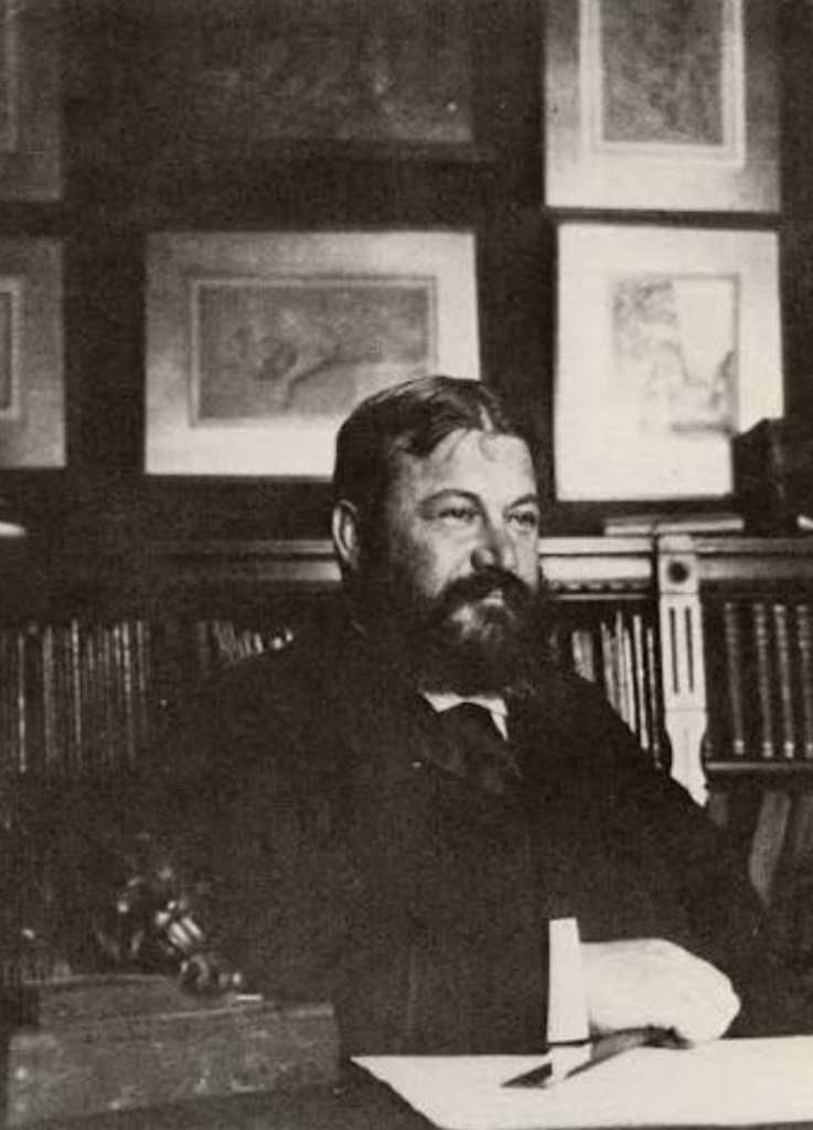
The founder of the Town of Strother – I.e.: Lee’s Summit – is William Bullitt Howard.

The name for the Town of Strother, paying homage to William Bullit Howard’s late wife, Maria Strother. 

Maria Strother died the same year William B. Howard filed his plat to establish the Town of Strother – 1865.

Land on which this new Missouri town would be erected totaled 70 acres. This 70-acre allotment which would go on to become Lee’s Summit was parceled out from the 800-plus acre Missouri plantation owned by William B. Howard.

Born and raised in Kentucky, William B. Howard moved to Jackson County, Missouri in the 1840’s. Coming from a wealthy family in the South, William B. Howard did not serve in the Civil War. As the War raged on, William B. Howard left Missouri. Returning to his native Kentucky. Preceding his later return to Missouri. Preceding the establishment of Lee’s Summit.

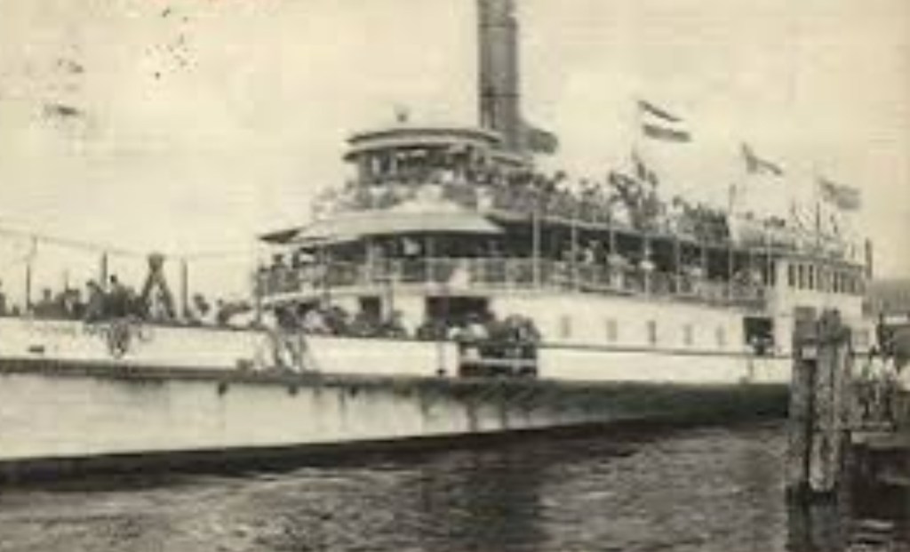
At War’s end, Howard did indeed return to his adopted Missouri. Returning to Missouri, while holding a belief that a pending rail connection of St. Louis to Kansas City would create opportunities in commerce. Opportunities which were sure to benefit William B. Howard. A large landowner. 

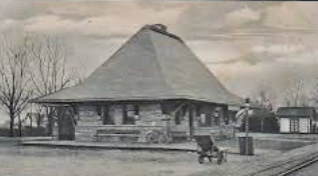
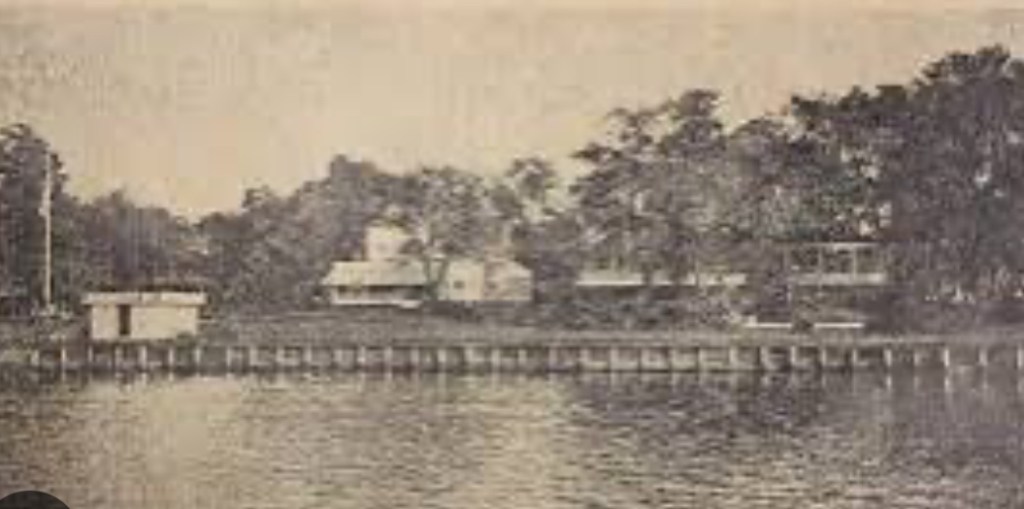
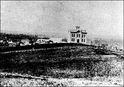
When the Civil War came to a close, recognizing the role rail was certain to play in a post-War economy – and in opportunities for growth in and around Kansas City – William B. Howard entered into negotiations with Missouri Pacific Railroad. Howard negotiated the construction of a new depot. A new depot which was to be built alongside Missouri Pacific Railroad tracks. Just south of Kansas City. On Howard’s land.

Missouri Pacific Railroad proceeded to build their new depot on Howard’s land in Strother.

Upon the incorporation of the Town of Strother in 1868, there was a name change for the town. From the Town of Strother. To Lee’s Summit.

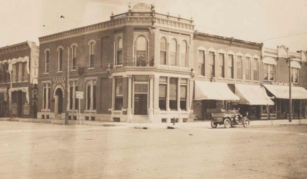
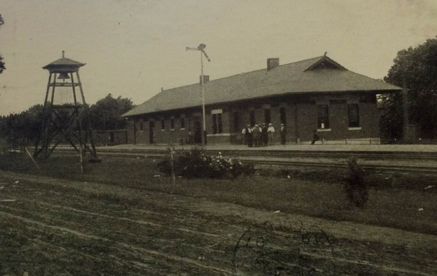
Construction of a second Lee’s Summit depot – the all-brick Missouri Pacific Depot which, still, is located in downtown Lees’s Summit, to this day – was completed years later. In 1905. 

The current Missouri Pacific Depot replaced the older, original boxcar station which had been built in the Town of Strother by Missouri Pacific. That old Missouri Pacific boxcar station, and one famous old boxcar parked at that old station, played a humorous yet important role in the town’s name. 

The Missouri Pacific Depot which would be built on Howard’s land enabled passengers to travel from Lee’s Summit to St. Louis. That railway connection, having been completed two years after Howard filed his original plat for the Town of Strother in 1865. The Kansas City-to-St. Louis rail connection was completed in 1867. Two years after Howard filed his plat to establish the Town of Strother. One year prior to the incorporation of Lee’s Summit.

The name change from the Town of Strother to Lee’s Summit is attributed to William B. Howard learning of another Missouri town which had also been named “Strother.”

The “Lee” in Lee’s Summit.

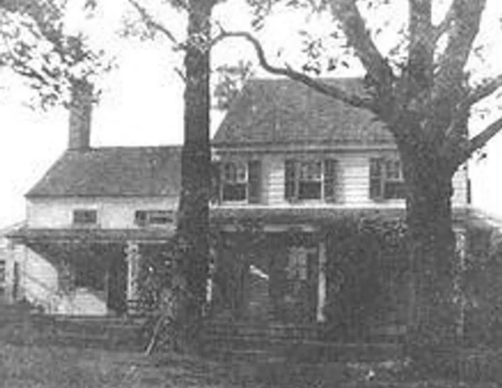
Upon relocating to Missouri, from Kentucky, William B. Howard resided in Big Cedar. In Jackson County. Among Howard’s neighbors and friends in Big Cedar had been the Leas. Pleasant and Lucinda Lea. 

Pleasant Lea was the local doctor. And postmaster. The Lea family and the Howard family grew to become close friends. Sharing more than their adjacent Missouri addresses. They shared also, their southern pasts.

The Leas moved to Jackson County from Tennessee. The Howards moved to Jackson County from Kentucky. Each family had been a wealthy, transplanted southern family. Establishing new homes for themselves just outside of Kansas City. In Civil War times. 

Pleasant Lea died in 1862. Three years before William B. Howard filed his plat to establish his Town of Strother. Which had originally been named for his late wife.

The change in the town’s name from the Town of Strother to Lee’s Summit involved another close relationship of Howard’s. His neighbor and friend, Pleasant Lee. 

Pleasant Lea, the origin for our “Lee” in Lee’s Summit.

Pleasant Lea resided in Big Cedar, to the south of Kansas City, prior to the Howards’ arrival. Pleasant Lea. The local doctor. The local postmaster. Pleasant Lea, William B. Howard’s close friend. 

It’s Pleasant Lea, spelled L – E – A , so why is it Lee’s Summit, spelled L – E – E?

What should have been spelled out as “Lea’s Summit” – Lea – on a boxcar at that old Missouri Pacific Depot in the Town of Strother, was simply a misspelling. 

That boxcar should have had Lea’s Summit” painted on it. L – E – A. The “Lea” denoting the correct spelling for Pleasant Lea’s last name – Lea.

Rather, that boxcar had “Lee’s Summit” painted on it. A misspelling. And so, going forward, the “a” in Lea’s was dropped. Replaced with the “e.” To arrive at, Lee’s Summit.

The “Summit” in Lee’s Summit.

The definition of summit is, the highest point of a hill or mountain.

The “Summit” in Lee’s Summit was coined in recognition of Lee’s Summit being the highest point on the Missouri Pacific line which ran from St. Louis to Omaha, Nebraska.

Lee’s Summit. The name for which we find a wealthy landowner, originally from Kentucky. The railroad. A neighbor. And an elevation point. 

Little Silver


Located 47 miles to the south of New York City, bordering Red Bank, Fair Haven and Rumson, home to 12-acre Parker, Sickles Farm Park, with a population of a cat’s whisker over 6,000 residents, we find the Borough of Little Silver. An exclusive community majestically nestled alongside the Shrewsbury River. This Monmouth County borough speaks to boating and water sports enthusiasts.

The beginning for Little Silver was that of a quiet agricultural community. With fisheries adding to the borough’s landscape in its earliest days.

Little Silver’s history dates back to 1663. To a King’s Land Grant. A land grant from Great Britain by the King of England, King Charles II.

Two years after King Charles’ land grant, a Rhode Island Quaker by the name of Peter Parker settled with his family in what went on to become Little Silver. This, in 1665. 

Our borough’s name of “Little Silver.”

The origin for “Little Silver” came about when Peter Parker named his new settlement in Monmouth County after his father’s Portsmouth, Rhode estate. His father’s Portsmouth estate, Little Silver. 

With Parker’s arrival along the Shrewsbury, neighboring settlements forming around Parker’s Homestead affectionately referred to the area as Parkerville. As a tribute to Peter Parker. 


The Parker Homestead was built in 1720. Built on today what would be Rumson Road, alongside Parker’s Creek.

Parker family descendants resided at the original Homestead for over three-hundred years. The last Parker residing at the original Homestead was Julie Parker. 

The last surviving Parker Homesteader, Julie Parker passed away in 1995. Her death marking an end to 330 years of uninterrupted occupancy at the original Homestead by a member of the Parker family. 

From early settlement, to destination point.

During the 19th Century the emergence of steamboats added to Little Silver’s guest list. With Patten Line Steamboats handling maritime transportation to and from Little Silver.

This topic of steamboat travel and Little Silver connect us to one steamboat captain in particular. A steamboat captain to whom an epoch found within Little Silver’s past is correlated. A steamboat captain whose signature was scripted to Little Silver in the 19th Century.


A steamboat captain: the founding father of Little Silver Point.

In 1844 a steamboat captain by the name of John Borden arrived in Little Silver. Relocating to Little Silver from nearby Red Bank. With his arrival in Little Silver, John Borden proceeded to establish Little Silver Point. An unincorporated section of Little Silver. 

Prior to the establishment of Little Silver Point, this peninsula in Little Silver’s northeast corner had been not much more than farmland. And soggy saltwater marshes.

The arrival of John Borden in Little Silver marked the beginning of a transformation for the peninsula.

Little Silver Point changed. Taking on a new identity. One scripted by the construction of fancy hotels on the peninsula.

Those early hotels built in Little Silver Point would accommodate visitors coming to a new Little Silver Point. On steamboats. Little Silver’s farms and marshes, no longer defining fabric for the peninsula.

John Borden’s lot in life had always been his pioneering of steamboats. Steamboats let New Yorkers come to Little Silver Point. Little Silver Point became a sought-after resort. Guests arriving in Little Silver Point atop steamboat decks.

John Borden passed his steamboat acumen on to his son, Richard Borden. Cementing the Bordens in Little Silver history, Richard Borden went on to operate Silver Bay House in Little Silver.

Borden’s Silver Bay House became the place to go for New Yorkers who came to Little Silver on Patten Line steamboats. 

Patten Line’s path to Little Silver’s riverside hotels was the Shrewsbury River. The Patten Line connected Monmouth County to Battery Park from the end of the Civil War to the 1930’s. 

It was a sixty year-run for those Patten Line steamboats which started their voyages in Battery Park. Arriving in Monmouth County on the Shrewsbury River.

Accompanying 19th Century steamboat travel, the advent of passenger trains contributed to Little Silver’s accessibility.

Construction of The Little Silver Train Station occurred in 1875. Little Silver’s station was built by the New York and Long Branch Railroad.

The original station in Little Silver served passengers for fifteen years. From 1875 through 1890. 

The original station was replaced in 1890 by the structure which still stands along tracks in Little Silver to this day. At the intersection where Branch Avenue meets Sycamore Avenue. 

The one-hundred thirty-six year old station we find in Little Silver at 705 Branch Avenue in 2026 gets commuters to Newark’s Penn Station. And New York’s Penn Station. 

The Little River Train Station, with its sandstone exterior and its distinct slate roof, was the creation of a famed architect from Brookline, Massachusetts.


The Little River Train Station architectural design is attributable to Henry Hobson Richardson.

Henry Hobson Richardson’s contributions to the American architectural landscape include The Little Silver Train Station, Trinity Church and the Boston Public Library.

Up through 1923 Little Silver had been part of Shrewsbury Township. Little Silver became its own municipality through an act of the New Jersey legislature in March of 1923.

Little Silver’s history is intertwined with the Shrewsbury River. This connection of borough to waterway, foretelling still Little Silver of today.

In 2026, nearly 10% of all homes in Little Silver touch the banks of the Shrewsbury River. 

Four hundred years after King Charles’ land grant to this riverside settlement, the river remains an anchor for the settlement.

Long, long ago, the Shrewsbury River functioned as a maritime agent for those visiting Little Silver Point. Today, the Shrewsbury River can be characterized as a waterway pillar. A waterfront pillar upon which a stock of distinct Monmouth County real estate now proudly resides.

Rumson, New Jersey…in the very beginning.


The Borough of Rumson is a charming seven square mile bedroom community of New York City. With two of those seven square miles, consisting of water.

Rumson is home to a tad more than 7,000. Long, long before Rumson became Rumson, Rumson was Navarumsunk. Or, Narumsum. 

Today’s Rumson was once Navarumsunk. This, when territory including the 7 square miles which would one day become Rumson was purchased by English settlers. English settlers who migrated to the area from New England. And from Long Island. English sellers purchased Navarumsunk from the Lenape Indians.

Negotiations for the sale of Navarumsunk to English settlers began in 1663. Two years later, Governor Richard Nicholls confirmed the land purchase. By way of the Monmouth Patent. The year was 1665.

Through attrition, over time, due to, in a nutshell, shall we say, convenience, the longer Indian denomination of Navarumsunk was shortened. Shortened, to Rumson

The origin for the borough’s name – Rumson – is seen in naming assigned by Native Americans. Navarumsunk. Navarumsum. Rumson.

Today’s Rumson resulted from this 17th Century land purchase. A sprawling acquisition of land, this sale by the Lenape, certainly was. Land sold consisted of one tract of land nestled in between the Navesink River and the Shrewsbury River.

Extending from today’s Sea Bright, to the east. Flowing west, to tributaries emptying into the Shrewsbury River. Today’s Rumson. 

Held by the English, Navarumsunk became Ramson’s Neck.

Ramson’s Neck was never a township. Ramson’s Neck was never a settlement. Ramson’s Neck included what would go on to become Rumson. 

The catalyst for our 1665 land purchase which became Ramson’s Neck, a section of which, later becoming Rumson, was found across “the Pond” – English colonial expansion.

A land conveyance by royalty in Great Britain can be pointed to as the reason there was a Ramson’s Neck. This same royal land conveyance also led to the establishment of Monmouth County. This was a conveyance of land in what was then Dutch territory – New Netherlands.

England’s king at the time was King Charles II. Charles II granted land in New Netherlands to his brother, James. The Duke of York.

The king granted to the duke a tract of unsettled land inclusive of today’s Monmouth County.

At the time of conveyance – from king, to Duke – New Netherlands was controlled by the Dutch. The English had their sight on taking this Dutch region for themselves. This, a land mass extending from what today would be Connecticut, going due south, to today what would be Delaware.

Charles II granted this entire Mid-Atlantic region – from Connecticut to Delaware – to his brother. James. The Duke of York. 

Upon receiving this land from his brother, the King of England, Duke of York authorized Governor Richard Nicholls to commence settlements. Settlements in what was still the Dutch’s New Netherlands.

Underpinnings for English settlements in Dutch territory emanated from the Monmouth Patent. 


The Monmouth Patent, understood best, within our context, was the assumption by Governor Richard Nicholls of a responsibility. A responsibility bestowed upon Governor Nicholls by the Duke of York.

The responsibility? To attract one hundred families to settle in this Mid-Atlantic Dutch territory. By 1668. Three years to accomplish the settlement threshold. Which led to, the Nicholls grant. With Governor Nicholls providing land grants for settlement.


The Nicholls grant was for land in Monmouth County, Ocean County and Middlesex County. Monmouth County, in which our Borough of Rumson resides.

Establishment of one hundred new English settlements within three years, aligned with the Monmouth Patent, included a prerequisite. A condition.

A condition was attached by Great Britain to Governor Nicholls’ land grants.

In order for what today is Monmouth County, Ocean County and Middlesex County to not revert back to the Duke of York from Governor Nicholls one hundred settlements were to take hold within the three year allotment.

The very first English settlers to arrive by way of Nicholls grants went in Shrewsbury village.

The Nicholls grant bestowed upon settlers a broad discretion. This, to govern themselves.

The “carrot” of self governance. An enticement to settle. These settlers were called, Patentees. Aptly named, because at the very core, these settlements came through the Monmouth Patent.

The Monmouth Patent, the Nicholls grant and Patentees. Emanating from Great Britain. The colonial goal? To establish one hundred new English settlements over three years. In Dutch territory. The expansionist colonial mindset of the British Empire.

The Monmouth Patent hit a bump in the road. British expansion, struck, and removed from uninterrupted accord. 

In 1674, the Dutch recaptured their New Netherlands territory. Taken back. From the English. 

While Dutch governance of New Netherlands (once again) proved to be a short lived reign, previous English grants – the Nicholls grant, the Monmouth Patent – were nullified. Through the change in imperial governance. From Great Britain. To Holland. 

Nullified, technically. Yet English settlements were not as alterable as would be flying a Vlag van Nederland (flag of the Netherlands) rather than the Union Jack over settlements.

By 1675, the English wrestled control of the Mid-Atlantic from the Dutch. 

Seven years later, the duke’s goal for Governor Nicholls to establish one hundred settlements was far surpassed. By 1682, four settlements were established in Ramson’s Neck and in surrounding land. Encompassing thousands of acres of plantations. Precursors to numerous cuter boroughs and townships. One of which being, Rumson.

Through the Revolutionary War times, Ramson’s Neck – today’s Rumson, Fair Haven, Red Bank, Little Silver and Shrewsbury – were sections within Shrewsbury Township.

Rumson was part of Shrewsbury for the next hundred years. Rumson became an independent borough in 1907. Rumson’s birthday is March 15, 1907. 

The Navesink and Red Bank


Fine arts and galleries. World class gourmet. Performing arts. The International Beer, Wine and Food Festival. The Guinness Oyster Festival. Red Bank.

And on the north side of this charming Monmouth County town, we find the Navesink River. Eight miles in length, the Navesink is the result of a confluence. This confluence being, the Swimming River and several smaller streams. One of the tributaries of the Navesink River is Shrewsbury River.

The Navesink River and Red Bank. We’ll revisit their longstanding relationship after a trek through Red Bank history. This relationship between a river and a settlement is tantamount to how Red Bank came to be.

The borough of Red Bank derives its name from red soil discovered on banks of the Navesink. Red banks. Red Bank.

A riverside town of just about 13,000 residents, Red Bank’s history was written through receipts received for benefits attributed to the river which touched that settlement’s red banks.

Our Red Bank story goes back to the 17th Century. To long before Red Bank became a town. To long before Red Bank became a borough.

Red Bank as a borough…

Red Bank became a borough in 1908. Created through an act of the New Jersey legislature.

Red Bank as a town…

Red Bank’s history as a town predates its formation as a borough. By thirty-eight years. In 1860 the town of Red Bank was formed. Formed from parts of Shrewsbury Township.

A land sale, a deed, a river and red banks. A land sale consisting of three acres which extended to the “red bank” of the Navesink River established boundaries for a settlement.

A settlement which became a town. A town which became a borough. Red Bank.

Then too, this three acre land purchase in 1736 constituted the naming of Red Bank. “Three acres extending to the red bank of the Navesink River.”

A land purchase. A deed description. And red banks along the Navesink.

Our Red Bank beginning as a trading post…

Red Bank became a trading post ten years after the town of Red Bank had been formed in 1860. In 1870 Red Bank became a trading post.

Red Bank during the 17th Century…

Two hundred years prior to Red Bank’s incorporation as a town, in the 17th Century, European settlers were drawn to this location nearby two rivers – the Navesink and the Shrewsbury.

English and Dutch settlers established trade relationships with Native Americans along these red banks. Native Americans who themselves found favor setting up camp along the Navesink.

The Lenapehoking were Native American tribes who lived in Lenape territory on the Navesink. Lenape territory included this area along the Navesink. As well as land located in what today is New York City, eastern Pennsylvania and northern Delaware. Land along the Navesink which was hunted and fished by Lenape was Navarumsunk.

As English and Dutch arrived in this settlement, Lenape found their new European neighbors to be capable trading partners.

Aside from their ability to set up trade networks with Native Americans, English settlers brought with them familiarity with an industry which had been a “national champion” in Great Britain. Shipbuilding.

In the earliest days of Red Bank, shipbuilding was formative to the local economy. A shipbuilding industry pioneered by English settlers took hold. Developing as the result of a natural circumstance: this was a settlement alongside a navigable waterway.

Through their ability to navigate the Navesink, English shipbuilders benefitted from a fast-growing economy in Manhattan.

As Manhattan’s economy developed around textiles, the Navesink became a convenient channel through which ships coming from Red Bank could reach Manhattan. A trade route, facilitating the transportation of Manhattan textiles.

Come the early part of the 19th Century, as the economy in this region matured, Red Bank shipbuilders found a new beneficiary: those who traveled from Red Bank to Manhattan.

Early on, textiles, tanning and furs produced in Manhattan served as “passengers” onboard ships built in Red Bank. The movement of textiles. Along the Navesink.

During the 19th century, as the populations of New Jersey and New York City grew, as the economies of New Jersey and New York City grew, Red Bank shipbuilders adapted to the changing economy. Transitioning from building ships exclusively to serve the textile industry to building ships to serve the textile industry and commuters. Commuters being, passengers traveling from Red Bank to Manhattan.

One hundred years after that deed recording which noted “three acres extending to the red banks of the Navesink River,” steamboats enter our Red Bank story.

In 1809, regularly scheduled steamboat service going from Red Bank to Manhattan was available.

By the mid-1800’s, traveling to New York City from Red Bank by steamboat became a mainstay. Steamboats could be seen chugging along the Navesink.

Steamboat travel on the Navesink enjoyed a one hundred year run. The very last steamboat set sail from Red Bank in 1931.

Today, the Navesink sits as a beautiful piece within the “Red Bank collection.”

Yesterday, the Navesink sat as the mechanism on which Red Bank’s development was based.

Red Bank and the Navesink. Partners today. Partners yesteryear. Partners for over 400 years.

Pemberton, New Jersey

The naming of Burlington County, New Jersey’s Pemberton goes back to late-17th times. In naming of a town, we find a link William Penn. To a prominent local mill. To a a successor to Benjamin Franklin. To an abolitionist. One who decried waging war on Indian tribes. 

The beginnings for the Pemberton’s…

In 1682, an Englishman by the name of Phineas Pemberton settled on 300-some acres along the Delaware River. Phineas Pemberton, arriving as a colonial settler in England’s new American colony of Pennsylvania. Arriving in Pennsylvania by way of Lancashire, England. Phineas Pemberton started his colonial journey in Maryland. Later, migrating north. To Pennsylvania.

Once settled in Pennsylvania, Phineas Pemberton proceeded to work closely with Pennsylvania’s founder, William Penn. Phineas Pemberton served as Chief Administrator of Buck’s County, Pennsylvania for William Penn. Across the Delaware River from where today we find Pemberton, New Jersey.

Phineas Pemberton’s arrival in Pennsylvania’s Buck’s County came one year after King Charles II granted an area of land across “the Pond” within the British Empire to William Penn. Or, to be more era-precise, to Sir William Penn. This land, granted to Sir William Penn as a debt payoff by England’s king. This had been money owed by England’s king to William Penn’s father.

Pennsylvania’s very beginning. On land which had once been – prior to falling under Britain’s rule – New Sweden. New Pennsylvania settlements were taking hold. This, a time of colonial settled. And colonial migration. Leading to population growth for the new Buck’s County. 

Hence, we have our framework for an entrance by the Pemberton family name into the annals of American history.

In Buck’s County’s, Phineas Pemberton became William Penn’s Chief Administrator. As William Penn’s Chief Administrator, Phineas Pemberton was responsible for record keeping pertaining to the arrival of new settlers in Buck’s County.

Phineas Pemberton became Clerk of all Courts for Buck’s County. Phineas Pemberton became Register of Wills for Buck’s County. Phineas Pemberton became Master of the Rolls for Buck’s County. Phineas Pemberton became Receiver of Proprietary Quit Rents for Buck’s County. Phineas Pemberton became Surveyor General for Buck’s County. Phineas Pemberton’s was, shall we say, quite an important man.

Be it calculations of Buck’s County cattle. Be it births in Buck’s County. Buck’s County deaths. Migration tabulations for new settlers arriving in Buck’s County. These records were being memorialized by William Penn’s Chief Administrator, Phineas Pemberton.

Phineas Pemberton…establishing groundwork in Pennsylvania for a Pemberton family member who would later go on to become Pemberton’s namesake.

It would be some fifty years after Phineas Pemberton’s record keeping exercises for William Penn that we’ll find our origin for what would go on to become the New Jersey community for which the Pemberton family name today remains affixed.

As we will find when we learn about the beginnings for so many American cities and towns, industry was at the forefront of the progression of this community towards a becoming, first, a borough. Then later, a township. And in Pemberton’s case, that American industry happened to a mill. A saw and grist mill.

In 1752, David Budd, together with a group of entrepreneurs, established New Mills Company. Recognizing how Pemberton’s access to a great natural waterway could provide power to his mills, David Budd built his first industrial mill twelve years prior to the founding of his New Mills Conpany.

Upon building his first area mill in 1740, David Budd’s New Mills Company proceeded to build additional mills. These were saw and grist mills.

David Budd’s original New Mills Company mill stood in a community which would later go on to adopt the name, for which, David Budd’s company provided the reasoning. The community became, New Mills.

Yet, New Mills at this time was not a township. Nor was New Mills yet a borough. At that time, part of this New Mills community was situated within New Hanover. While another part of this New Mills community was situated within Northampton. Northampton, today’s Mount Holly.

Nonetheless, what was then New Mills was very much a burgeoning community. Growing around David Budd’s saw and grist mills. Across the Delaware River from where Phineas Pemberton earlier served as William Penn’s record keeper.

As the 18th Century faded, becoming the 19th Century, this mill community of New Mills would go on to adopt its new name: Pemberton.

These old sections of New Hanover and Northampton, together making up New Mills, broke off from their respective townships. They broke off to form a new borough. This township break-off is where we find the origin for the borough of Pemberton.

The borough of Pemberton – this, which once had been known as New Mills – was incorporated as a New Jersey borough in March of 1826. Pemberton was later incorporated as a New Jersey township. That happened twenty years later. In 1846.

We have Phineas Pemberton, William Penn’s numbers cruncher. We have New Mills Company. And David Budd. We have our township name, Pemberton.

While Phineas Pemberton and David Budd were locals of great importance to this region within New Jersey’s Burlington County, neither of these two men ended up becoming the reason for why Pemberton today goes by the name of Pemberton.

Pemberton is really Pemberton due to values espoused by an abolitionist from Pennsylvania. James Pemberton 


James Pemberton. The Pennsylvania Quaker who succeeded Benjamin Franklin as President of the Pennsylvania Abolition Society.

The New Mills borough renaming which took place in 1826 – from New Mills, to Pemberton – was an undertaking to honor that successor to Benjamin Franklin. He who headed up Franklin’s anti-slavery organization, after Franklin’s departure. An anti-slavery movement in Pennsylvania which was led by the Pennsylvania Abolition Society. Carried onward by James Pemberton. So as to ensure that the institution of slavery would not become one pillar on which this new country of America would be built.

James Pemberton. A founder of Pennsylvania Hospital. President of Benjamin Franklin’s Abolition Society. Influential area landowner. Member of the Pennsylvania Assembly…resigning from the Pennsylvania Assembly due to the fact that the governor of his State declared war on Indian tribes. Phineas Pemberton’s grandson.

James Pemberton. Our namesake for Pemberton.

Council Grove, Kansas


What is so very interesting about our nation’s history can be discovered through historical connections we make between famous Americans, and quite often, places we frequent. Or, places we visit. Or, in my case, the restaurant which serves the best bread pudding.

One of my – How did this come to be? – started off as an affinity for bread pudding. Bread pudding in Council Grove, Kansas. Bread pudding served at Hays House 1857.

Hays House 1857, Daniel Boone, Benjamin Franklin and Council Grove.

Council Grove’s origin…


In the earliest part of our nation’s 19th Century, in what would – 29 years later – go on to become the Territory of Kansas, in 1825, westward-focused American settlers had been eager to identify quicker (and better) trade routes. With this impetus for expanding trade to the west in mind, a treaty in 1825 had been negotiated between United States commissioners and the Osage Indians. Negotiated in a section of the Great Plains where frontiersmen gathered. Rested. And congregated. Before continuing on…west.

In the early part of our 19th Century in what today is Kansas, as United States trade – and as United States trade routes – were being expanded to the west, one 1825 treaty entered into by the United States with Indians – the Osage Indians – grew what would go on to become one of the most famous passageways – passageways, trails, routes, roads and/or highways… – in all of United States history. 

This trail…a 900-mile United States trade route. 


This trail…starting out in a small town, 100 miles to the east of Kansas City, Missouri.

This trail…its origin, a small town which had been founded by European setters in 1816. 

This trail…beginning in that small Missouri town – to the east of Kansas City – which had been named for one of the United States’ Founding Fathers.

This trail…which one would, at that time, start their travels on in Franklin, Missouri

Franklin, Missouri…a town named for one of the United States most famous Founding Fathers, Benjamin Franklin.


This trail…ultimately arriving in, Santa Fe, New Mexico.

This famous trail we are speaking to? The Santa Fe Trail. 


The treaty between United States commissioners and the Osage Indians extended our Santa Fe Trail to the west. Through a section of what would later go on to become, the Territory of Kansas. Later becoming, the State of Kansas. 

This treaty entered into between United States commissioners and the Osage Indians – in 1825 – was centered upon a destination point for frontiersmen traveling west. At the “Grove.”

In 1825, there was no incorporated United States town through which this section of the Santa Fe Trail had been extended. 

In 1825, there was no organized territory through which this section of the Santa Fe Trail had been extended.

This 1825 treaty – extending the Santa Fe Trail though a most-scenic part of the largest tall grass prairie in the United States, the Flint Hills – focused on an area in the Plains where travelers gathered their wagons. They’d form wagon trains. And they’d head west. From the “Grove.”

We are referring to an area in Kansas’s Flint Hills which was at that time – to the Osage Indians, and to frontiersmen – simply known to be, the “Grove.”

The “Grove.” Named for a grove of trees

This 1825 extension of the Santa Fe Trail would wind along – what had been at that time – simply, the main street in the “Grove.”

The unincorporated territory in which this section of the Santa Fe Trail had then been extended – in 1825 – would go on to become a formal United States Territory. In 1854. This territory would go on to become the Territory of Kansas.

This grove of trees would go on to become an incorporated United States city. Twenty-six years after the Territory of Kansas became the State of Kansas in 1861. The grove of trees would go on to become…Council Grove

Council Grove was incorporated as a city in Kansas in 1887.

And that old main street in the “Grove?” Our old main street would go on to become …Main Street. In Council Grove


Which brings us to our link between the “Grove,” the Santa Fe Trail, Council Grove and…Daniel Boone.

But first…Seth Hays.

Hays house ( lower case “h”) started serving American pioneers three years after the Territory of Kansas was incorporated as a United States territory. 


In 1857, Hays’ house originally started out as a Santa Fe Trail trading post. A Santa Fe Trail trading post coupled to a Santa Fe Trail restaurant. Located – then, and now – on the Santa Fe Trail. 


With its historical position, quite literally, on the Santa Fe Trail, the Hays house traces back to Seth Hays.


Seth Hays. Founder of Council Grove, Kansas.

Seth Hays. Rancher. Tavern owner. Trader. Publisher.

Seth Hays, who grew up in the Kansas City, Missouri neighborhood of Westport.

The original Hays house? Well, the original Hays house that Seth Hays built next to the Neosho River wasn’t actually a house.

The original Hays house was in fact a log cabin. A log cabin which functioned as Seth Hays’ home – I.e.:. where Seth Hays lived with his adopted daughter, a freed slave. And as a Santa Fe Trail trading post. 


The trading post built by Seth Hays in the “Grove” was a business venture headed by a relative of his, A.G. Boone. 

A.G. Boone…grandson of Daniel Boone.

Seth Hays…great-grandson of Daniel Boone.

Boston, a hill, limestone, abolitionists plus one rendering from a cartoonist…Lawrence, Kansas


Lawrence, Kansas was founded by a group of New England abolitionists. Abolitionists who were intent on establishing a new community where people of all races would be free. Culminating in Lawrence’s determination to ensure that Kansas – then…a territory – would be admitted to the United States as a “free state.”  

Lawrence was founded in 1854. Seven years prior to Kansas becoming the 34th State.

Nine years after the founding of Lawrence – in 1863 – then-Kansas Governor Thomas Carney signed a bill into law creating the second state university in Kansas. This university was to be built on 40 acres – the University of Kansas. Founded in 1864.

This university for Kansas – the second university within the Sunflower State – was to be constructed on Hogback Ridge. Hogback Ridge in Lawrence. Hogback Ridge, later becoming, Lawrence’s Mount Oread.


The relevance to Mount Oread? And to Mount Oread’s role in that which Lawrence is most famous for? This can be found under our feet.

Three years after Governor Carney signed into law the bill which would establish a Kansas university in Lawrence, classrooms at the University of Kansas first opened. This Lawrence university first started out as a preparatory school. With fewer than 100 students.

Back to Mount Oread…

Mount Oread – that section of Lawrence on which KU was built – sits on a bed of limestone.


Limestone is chalk rock. Chalk rock – transposed – becomes rock chalk.

Hence, our famous, Rock Chalk Jayhawk.

Rock chalk. Chalk rock. Chalk rock sits below KU’s classrooms as the – quite literally… – as the foundation of the university.

Our chant? Rock Chalk? That chant – originating in the chalk rock of limestone found in Lawrence’s Mount Oread – was originally a slogan used by the university’s science club. A science club slogan.

Let’s go back to that group of New Englanders who established Lawrence…

Those New Englanders who first established Lawrence were not so much a loosely-aligned abolitionist group at all. No, Lawrence’s forefathers were actually an organized company. This company? The New England Emigrant Aid Company.

The New England Emigrant Aid Company had been a Boston-based transportation company. Established to transport those who opposed slavery into this new Kansas Territory out west.

As abolitionists, the idea espoused by the New England Emigrant Aid Company went along these lines…

Through New England Emigrant Aid Company’s transportation of anti-slavery immigrants who would settle – en masse – in the new Kansas Territory, the politics within the Kansas Territory would then favor the abolishment of slavery. Not the expansion of slavery. Abolitionists.

As such, with sentiment taking hold in the new Kansas Territory which frowned upon the institution of slavery, Kansas would then (ideally) choose to join the United States as a free state. Not as slave state. Which it indeed did. in 1861.

Rock chalk. That’s about limestone. Limestone underneath the KU campus. 

And after Rock Chalk we find…Jayhawk.

Rock chalk…limestone. So, how about the Jayhawk part of our slogan? 

Any conversation one has about the Jayhawk part of this famous slogan from Lawrence brings us back to Lawrence’s idea for Kansas to join the Union as a free state. To efforts undertaken by the New England Emigrant Aid Company. And to Lawrence’s abolitionist “DNA.”

Prior to Kansas becoming a state in 1861, Kansas abolitionists battled pro-slavery factions. Factions who were intent on seeing Kansas join the Union as a slave state. Not as a free state. Those Kansas abolitionists we are referring to here were known as jayhawkers


During the 1860’s, jayhawkers were not only found in this new Kansas Territory. No, jayhawkers could also – at that time – be found throughout the Midwest. All the way down to Texas. The abolitionist movement of the 1860’s…native to the Midwest. Jayhawkers.

Yes, jayhawkers are most closely aligned with the State of Kansas. The Kansas Jayhawks. This is attributed to the Bleeding Kansas era. The period of violent conflict over the issue of slavery which took place prior to the outbreak of the Civil War.

Between 1854 and 1859, murder, violence, the destruction of property and total mayhem took hold in Eastern Kansas and Western Missouri. Bleeding Kansas.


Kansas and abolitionists. Lawrence and Kansas’s university. The University of Kansas and jayhawkers.

The University of Kansas officially adopted the Jayhawk as the school’s mascot in the year 1923. 

That duck-like bird we now know to be our KU Jayhawk? No, there is no winged-jayhawk bird flying over the beautiful prairies of Kansas. No, there is no winged-jayhawk bird which has ever flown over those beautiful Kansas prairies.

That famous duck-like bird we find under 16 Final Four banners in Allen Fieldhouse? That bird is an artistic creation.

The most famous abolitionist logo in the history of sports can be traced all the way back to 1912.

In 1912 Henry Malloy was a cartoonist working for The University Daily Kansan – KU’s newspaper.

Henry Malloy – in 1912 – drew a picture of one shoe-wearing bird. And released his picture of his shoe-wearing bird in The University Daily Kansas. Our first jayhawk.


In 1923, eleven years after Henry Malloy created that very first jayhawk cartoon rendering, two KU sophomores – Jimmy O’Bryon and George Hollingbery – created the rendering more-closely based on the duck-like bird we find today in Allen Fieldhouse.

Boston…

Abolitionists…

A hill…

Limestone…

A cartoonist…

Two college sophomores…

Lawrence, Kansas.

The year 1900 brought us The Gold Standard Act and The Wizard of Oz

The Gold Standard Act was signed into law on March 14, 1900 by President William McKinley. The Gold Standard Act made gold the singular standard for the United States currency. 

The book – The Wonderful Wizard of Oz – was published on May 17, 1900. The book was written by L. Frank Baum.


L. Frank Baum’s book is about the American monetary system… just as the 19th Century ended, and the 20th Century began.

The Wonderful Wizard of Oz.

Oz is the abbreviation for ounce. An ounce of gold. Gold, the new currency standard. An ounce of silver. Silver, the replaced currency standard.

Twenty-seven years prior to The Gold Standard Act…twenty-seven years prior to Baum’s book, the Coinage Act of 1873 was signed into law by President Ulysses S. Grant.

The Coinage Act of 1873 officially replaced silver with gold as the standard for the United States currency. The Gold Standard Act expanded upon what went into effect through the Coinage Act, twenty-seven years prior.

The yellow brick road in The Wonderful Wizard of Oz is representative of the new American currency standard, gold.

Dorothy’s silver slippers are representative a replaced currency standard, silver. Gold and silver are measured in ounces. Hence…Oz. The Wonderful Wizard of Oz.

in the movie, Dorothy’s slippers are red. Red slippers? Red has no meaning. The movie strays from Baum’s book. Dorothy’s red slippers…just do not fit here.

In Baum’s book Dorothy’s slippers are silver. Silver. With meaning.

The book – much moreso than the movie – represents Baum’s views. In 1900.

An ounce – I.e.: Oz – of silver. An ounce – I.e.: Oz – of gold.