Processes to consider when thinking through how to transition abandoned homes from absentee owners to developers could include: a) land banking, b) spot blight eminent domain, and c) receivership. Tools. Why focus on this problem? Why cultivate ideas? Why develop solutions?
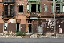
Abandoned homes become financial drains on a city’s resources. For example, the cost to demolish an abandoned home?Demolition costs could reach up to $20,000. Per home.
And there are social costs as well…
Neighborhoods with abandoned homes become breeding grounds for crime. For drug use. For violence. Social costs.
But social costs are not always correlated to dollars and cents. Furthermore, social costs are often viewed as someone else’s problem.
But are social costs easy to understand? Are social costs someone else’s problem?
Social costs attributed to abandoned homes correlate to financial costs. Financial costs incurred by the city. Financial costs incurred by the city’s stakeholders. Financial costs incurred by the city’s taxpayers.
Social costs attributed to abandoned homes affect city residents who may – at first – believe abandoned homes would not be a problem affecting them.
For example…
A New Yorker living in Tribeca or on the Upper East Side is part of New York City. As such, they pay New York City taxes. So, while there may be few abandoned homes in their neighborhood, Tribeca and the Upper East Side are still coupled to the poorest neighborhoods in New York City. To the Morrisania and the Crotona neighborhoods in the Bronx.
In Morrisania and Crotona, nearly 4-out-of-10 live below the poverty line.
Let’s say socioeconomic challenges in Morrisania or Crotona lead to a foreclosure in either neighborhood. That foreclosure, then becoming an abandoned home.
Increased police patrolling is one byproduct of abandoned homes. Enacted to prevent neighborhoods from spiraling into crime magnets.
Increased New York City police patrolling in the Bronx is a financial cost. Which addresses the social cost. And that is a New York City cost. A cost which is bourne by…Morrisania residents. A cost which is bourne by…residents on the Upper East Side. A cost which is bourne by…residents in Tribeca. A cost which is bourne by…Crotona residents.
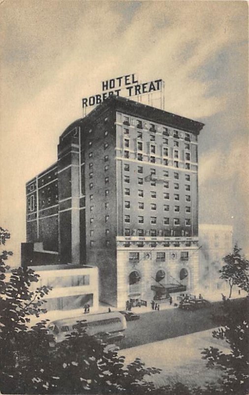
The Robert Treat Hotel opened to the public in Newark, New Jersey in the year 1916. This prominent hotel – located on Park Place in downtown Newark – was the first luxury hotel ever built in Newark.
The Robert Treat is named after the very man to whom Newark owes its status as, first, a territory of Great Britain. Then later, as a township in the American colonies. Then later, as New Jersey’s largest city. This man, was Robert Treat.
Robert Treat was born in England in 1622. Robert Treat arrived in the British colonies – in Massachusetts – in 1630.
In 1666, Robert Treat established a new territory for Great Britain. This new territory being, “Newark.”
What evolved into Newark was established by Robert Treat as the third New Jersey settlement. Great Britain granted this new territory a royal charter…forty-five years after Robert Treat first arrived in Brick City. This royal charter having been granted by Great Britain to Treat’s territory in 1713.
One-hundred thirty-two years after Robert Treat established this new territory for Great Britain, Newark was incorporated as a township in the newly-established United States. That occurred in 1798. As Newark Township. Through an act of the New Jersey Legislature – the Township Act of 1798. Through the Township Act of 1798, Newark became one of the New Jersey’s original 104 towns.
It was Newark Township up through 1836. In 1836, Newark Township was reincorporated as a city. Newark Township was no more. From 1836 on, it was simply, Newark.
At its origin – upon Treat’s arrival, while still a territory which was governed by Great Britain, long before there even was a New Jersey Legislature – Newark was not known as Newark Township. Nor as Newark.
At first, upon Treat’s arrival, this new Newark territory had been Pesayak Towne. The territory later became New Milford. Names for Newark…long before the territory Treat established became Newark Township. Then later, simply, Newark.
Prior to traveling south a bit from his native New England to what today is Newark – traveling…together with a fellow group of Puritans…as Robert Treat was a Puritan himself – Robert Treat had been a Connecticut governor.
From 1683 to 1687 Robert Treat served as Connecticut’s governor. Robert Treat served a second, non-consecutive term as the governor of Connecticut as well. Governor Treat’s second gubernatorial term in Connecticut ran from 1689 to 1698.
Health club privileges. A free shuttle to Newark Liberty International Airport. A business center. A guest lounge. Banquet facilities…
As we approach The Robert Treat Hotel’s 100-year anniversary, that’s what you’ll find today when you stay at The Robert Treat. Its colonial history…long since having evolved into the finest hotel stay that New Jersey has to offer.
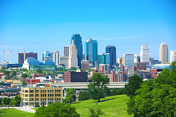
As the beginning of the Twentieth Century dawned in the Midwest, in Kansas City, streetcar suburbs came to be.
Early in the Twentieth Century, one streetcar line ran right down Troost Avenue. In the very heart of KC.
In the early-1900’s, one could jump on that Troost Avenue streetcar. Leave the hustle bustle of Kansas City. And arrive at one of Kansas City’s new streetcar suburbs.
Those new streetcar suburbs which were then being built in Paris of the Plains were still located in Kansas City. Yet, Kansas City’s streetcar suburbs did not espouse an urban feel. Manheim Park was one of those early Kansas City streetcar suburbs.
To the north, Manheim Park is bounded by 35th Street. To the west, Manheim Park is bounded by Troost Avenue. Troost Avenue…where one could jump on that Kansas City streetcar – early in the Twentieth Century – and be dropped off in Manheim Park – one of KC’s new streetcar suburbs.
The construction of new homes in Manheim Park took hold very early on in the 1900’s. Drawing upon a general distaste for how new Kansas City homes were then being constructed along, what oftentimes were, run-of-the-mill, plain vanilla roads that ran straight – either east-west or north-south – homes which were being built, in the opinion of early Manheim Park developers, too close to one another, no less. In Manheim Park, things would be somewhat different. In Manheim Park, your drive in to one of those new Manheim Park streetcar suburb homes was going to be…a drive along a new road with a unique contour.
Crooked roads…
To build new homes on any undeveloped land you need roads. And in Manheim Park, those new roads went in. Roads which did not necessarily run east-west. Roads which did not necessarily run north-south.
Those original Manheim Park roads were crooked. Creating a staple – all its own – for Manheim Park: its crooked roads
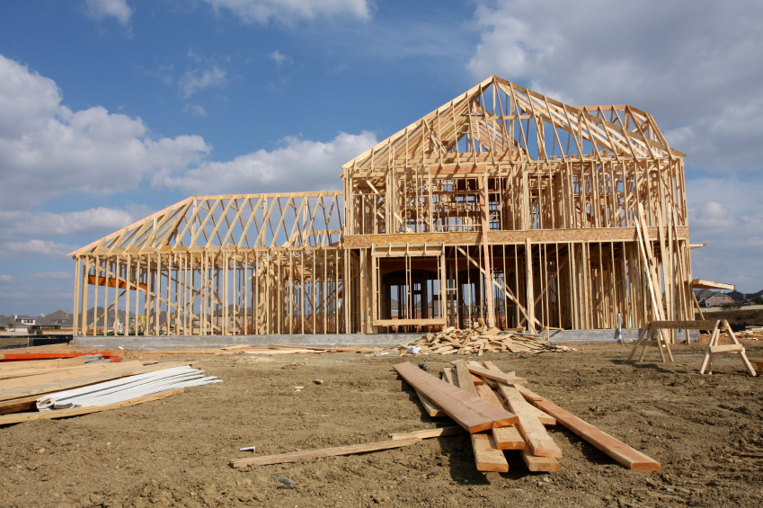
Our industrywide over reliance on selling already-built, move-in ready homes – I.e.: resales – prioritized over building business models which are predicated on building new homes, creating additional housing inventory and marketing new home construction options to home buyers has contributed substantively to housing inflation. As well as to sales numbers – in 2024 – which are comparable to sales numbers we saw thirty years ago.
Sometimes the correct answer includes plain old hard work. Coupled to changed perspectives.
Kansas City, Kansas’s beginning came to be by way of a merger of towns. A merger of towns which then became KCK neighborhoods.
In 1886 Kansas City, Kansas was formed when the independent settlements of Kansas City, Wyandotte City, Armstrong, Riverview and Armordale combined.
Twenty-four years later, Kansas City annexed Argentine. Argentine was built around smelting and mining plants. Argentine’s plants, benefitting from Argentine’s location alongside the Santa Fe Railroad.
Today’s KCK neighborhood of Argentine borders Rosedale.
Prior to its annexation by Kansas City in 1922, Rosedale had been The Town of Rosedale. Settled in 1872.
Annexed by Kansas City in 1923, Quindaro was originally a free state port alongside the Missouri River. Within the abolitionist movement, Quindaro was once an Underground Railroad station.
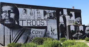
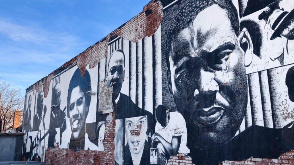
There is an interesting, historically significant 10-mile street in Kansas City, Missouri which runs from 4th Street to Bannister. The Kansas City, Missouri street I am referring to here is Troost Avenue.
Among the Kansas City, Missouri neighborhoods which border Troost Avenue are…Beacon Hill, Longfellow, Squier Park, Rockhill and Hyde Park. All are fabulously sought-after KC neighborhoods.
Troost Avenue was named after a doctor – Benoist Troost. Dr. Troost, as well as being a prominent Kansas City physician, had been a civic leader in KC. Troost Avenue.
Troost Avenue was once home to “Millionaire’s Row.” Early in the 20th Century, “Millionaire’s Row” had been a strip of stunning mansions constructed all along Troost Avenue. Those mansions adorned Troost from 31st Street to 34th Street.
Today, Troost Avenue is experiencing keen interest. And a tasteful renaissance of redevelopment. In times past, Troost Avenue experienced a storied history of disinvestment. And decline. Prior to Troost’s renaissance. So what led to Troost’s decline?
Disinvestment. But real estate disinvestment was not the primary catalyst which led to Troost’s mid-20th Century decline. Real estate disinvestment certainly was one catalyst which led to Troost’s decline. But real estate disinvestment was not the primary catalyst which led to Troost’s decline.
Disinvestment in public schools east of Troost was the primary catalyst which led to Troost’s decline.
Starting off in the late ‘60’s, the School Board in Kansas City, Missouri consistently requested increases in education funding for Kansas City, Missouri schools located east of Troost Avenue. For this topic, there were in the range of twenty such education funding requests made by the Kansas City School Board during this time. These were funding requests made throughout 1960’s. Throughout the 1970’s. For twenty years.
The additional funds – if approved – would have gone to Kansas City, Missouri public schools east of Troost Avenue. Funding requests were voted down. The result? White flight.
Families – those having the means, that is…meaning, predominantly white families at that time – moved. Families moved outside of the underfunded Kansas City, Missouri School District. Schools east of Troost were underfunded.
White flight. Neighborhood home values decreased. One prominent Kansas City mayor once referred to Troost Avenue as, “…the demarcation line in a war zone.”
The problem – east of Troost – wasn’t the legal segregation of schools. Nor was the problem – east of Troost – the illegal segregation of schools. The problem – east of Troost – was school funding. Or a lack thereof.
Long before round after round after round after round of failed requests were submitted to secure funding for Kansas City, Missouri public schools east of Troost, those same public schools were in fact desegregated. Yet school desegregation didn’t really solve this problem in Kansas City east of Troost. Because while school desegregation based upon race was the national mandate after Brown v. the Board of Education, decisions made which affected education funding were – and are – made at the local level. And therein was the problem for public schools east of Troost. At that time.
In 1954, the United States Supreme Court unanimously ruled in Brown v. the Board of Education of Topeka, Kansas that state-sanctioned segregation of public schools was unconstitutional. Prior to this 1954 Supreme Court ruling, in Kansas City, Missouri – east of Troost Avenue – Lincoln High School had once been the only high school providing post-elementary education to Black students. One high school.
In 1955, one year after Brown v. the Board of Education, the Kansas City School Board kind of enacted a “segregation” of public schools, in a different way. This was like a “de-facto segregation.” Not based upon race. But rather, this was a different form of segregation which was based upon attendance zones. Not race.
Yet, do we recall the aforementioned white flight east of Troost? The white flight which took place as round after round of funding requests for schools was voted down? Which led to panic selling? Which led to block busting? As white families relocated out of the Kansas City, Missouri school district?
Kansas City, Missouri public schools east of Troost were not segregated based upon race after the 1954 Supreme Court decision. But yet, in a practical sense, they kinda still were.
The city’s expansion…
Beginning in the 1950’s, and extending onwards through the 1960’s, Kansas City, Missouri – as a city – grew. During this time, Kansas City, Missouri added over 200 square miles to the city’s footprint. Yet, during this same time, what about Kansas City, Missouri public school sizes? What about Kansas City, Missouri public school teacher count? What about Kansas City, Missouri public school classroom sizes? What about Kansas City, Missouri public school classroom capacity?
None of those public school categories grew in a commensurate way – east of Troost, that is – to Kansas City’s population growth. Nor to Kansas City’s expanding public school education requirements. During the city’s expansion in the ‘50’s and ‘60’s – east of Troost – Kansas City, Missouri public schools remained overcrowded. And underfunded. The city’s expansion just made it worse.
In real estate, developers often utilize – and benefit from – tax abatements. On Troost Avenue – and east of Troost – there is a genuine renaissance which has taken hold. It’s long overdue. And it’s welcomed.
Let’s go back for a moment to the topic of Kansas City, Missouri public schools, east of Troost. To the underfunding of public schools, east of Troost. To classroom sizes…
The definition of a tax abatement is, the reduction of, or the exemption from, taxes granted by a government for a specific period, usually to encourage certain activities.
Over one six-year period – between 2017 and 2023 – Kansas City, Missouri public schools lost in excess of $200 million in potential education funding which could have gone (but didn’t go) to Kansas City, Missouri public schools. Funds redirected away from Kansas City, Missouri public schools due to development incentives given out. Development incentives coming from tax abatements.
Public schools in Kansas City, Missouri have accrued nearly $400 million in deferred maintenance. Underfunded.
Those of us who love Kansas City applaud the spectacular redevelopment which is taking place on Troost Avenue. Still, it’s not really a stretch for us to take a moment and think about what led to Troost’s decline. It was the schools.
If the #1 goal is redevelopment and private schools…all good.
While panic selling and block busting were two factors which contributed to neighborhood disruption east of Troost long, long ago, neighborhoods east of Troost will experience no such disruptions this time. As the “Troost pendulum”swings all the way…in the other direction.
What we’ll see is, not decreasing property values east of Troost. We’ll see increasing property values east of Troost.
We won’t see panic selling east of Troost. We’ll see home sellers fetching ever-increasing prices for their homes, east of Troost.
We won’t see blockbusting, east of Troost. We’ll see continued investor interest in homes, east of Troost.
What we’ll also see – east of Troost – is community members being priced out of their neighborhoods. We’ll see gentrification. We’ll see investment. Not disinvestment. We’ll see tax abatements.
We’ll also see hundreds of millions of dollars in deferred maintenance which has already been incurred by Kansas City, Missouri public schools.
We’ll see challenges in education. Different education challenges. Not segregation. Not the same challenges as before. But challenges in education east of Troost, nonetheless.
If redevelopment on Troost Avenue is the goal, all good.
If there are other topics to consider, maybe we revisit Kansas City history? Focusing on this topic: public schools east of Troost.
Within a Redevelopment Area, a municipality’s goal could be to transition residential, commercial and industrial properties within the Redevelopment Area into vibrant community assets. The pursuit of which could take on a community-centric theme. Renovations, repurposing properties, new home construction… Goals pursuant to the redevelopment of properties within a Redevelopment Area.
Redevelopment of properties within a Redevelopment Area could start out with a city council resolution. To redevelop properties. With the resolution, a planning board might then choose to construct a Redevelopment map. With a Redevelopment map – and upon notification to the public of an upcoming hearing – a planning board could then look to adopt a Redevelopment resolution. The resolution could recommend the establishment of a Redevelopment Area within the municipality.
Potential steps a municipality could consider beginning with in order to establish a Redevelopment Area within the municipality…
You can direct any comments or questions to Ted Ihde.
During the latter part of the 19th Century, goods making their way to the Western-most points of an ever-expanding United States would have likely ended up trekking through Paris of the Plains. Through Kansas City. Through Crossroads.
Kansas City was (and is) truly an American Crossroads.
In a fast-industrializing early-20th Century United States, Kansas City – I.e.: Crossroads – connected an industrial Northeast to agricultural centers in the American west. And in the American southwest.
The Santa Fe Trail. Kansas City’s unique location at the confluence of two major rivers – the Kansas River and the Missouri River. And later, as a major railroad hub. A railroad hub which, during its heyday, was second only to Chicago’s railyards in terms of rail traffic, and rail capacity. Each converged in Kansas City. Kansas City became a Crossroads. Due to its geographical location. Due to America’s expansion west. Due to rail. Due to trade patterns. Crossroads…
Lewis and Clark arrived in Crossroads at the onset of the 19th Century. Lewis and Clark arrived in Crossroads at a time when the United States government was keen on opening up the west to American interests. The most effective pathway west at that time? That would have been the Missouri River. Kansas City was built alongside “Big Muddy.” Built alongside the Missouri River.
Switching eras. Fast forwarding in time. Switching methods of transportation. Yet staying on the subject of Crossroads..
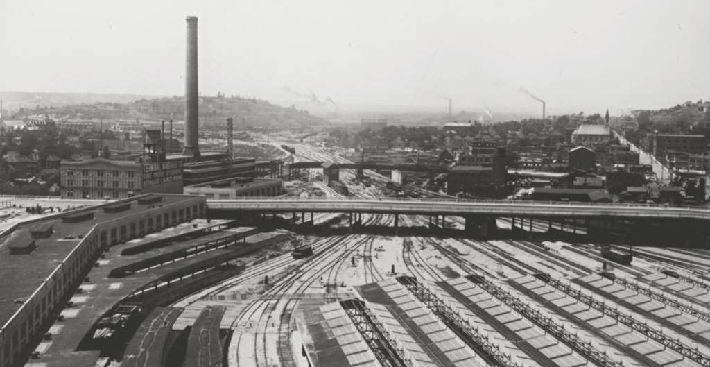
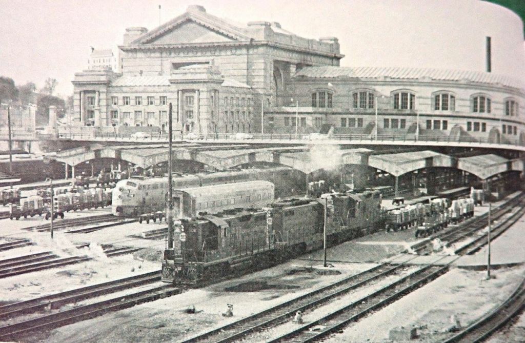
In order to facilitate Kansas City’s unique position as an American Crossroads, nearly 100 years after Lewis and Clark arrived with their team of 50 – and 3 boats – by the late-19th Century, the first train depot opened in Kansas City. The year was 1878. And that Crossroads train depot would have been Kansas City’s Union Depot.
Kansas City’s Union Depot became the second union depot which opened in the United States. Indianapolis’s union depot was the first.
By 1945, nearly 700,000 rail passengers stepped foot in Kansas City’s train station. At its height, close to 200 trains pulled into Kansas City every single day. Crossroads.
A Crossroads. A gateway. To an exciting new 19th Century American frontier. A Crossroads for 20th Century American train travelers. A Crossroads for American soldiers during wartime. A Crossroads for American industry. A Crossroads for freight trains. Crossroads.
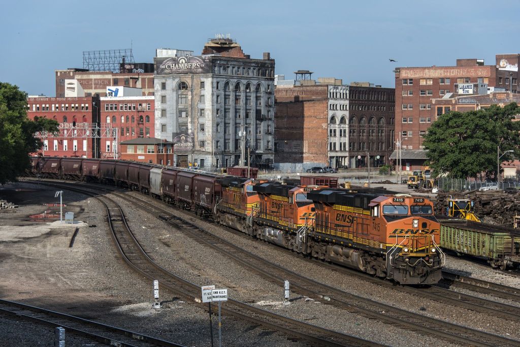
In the mid-20th Century, rail was the preeminent method of transportation for freight. In the mid-20th Century, rail was the preferred method of transportation for civilian passengers. As an American Crossroads, Kansas City quickly outgrew its original Union Depot.
Desiring – and requiring – additional capacity for their freight trains, the railroads which were collectively utilizing Kansas City’s Union Depot in KC’s industrial West Bottoms made a decision. Their decision? They were going to replace the outdated, ill-sized Union Depot with a new, larger more accommodative train station. Built in a new location. Union Depot was out. A depot in the West Bottoms – as the West Bottoms was prone to floods – was out. The new Kansas City train station would be near Kansas City’s central business district. Not in a floodplain. Built up on the hill.
Kansas City’s Union Station opened to the public in 1914 – a 850,000 square feet major railway hub. Union Station prospered. Rail, at that time, was an integral part of Kansas City’s position as an American Crossroads. Yet, as Union Station – and as rail – cemented Kansas City’s Crossroads status, macro circumstances in the United States changed. Macro circumstances changed the future of Kansas City’s Union Station. Macro circumstances changed the utilization of Kansas City’s Union Station. Macro circumstances changed the fate of Kansas City’s Union Station.
As the 20th Century progressed, the preferred method of transportation in the United States changed. For civilian passengers. For industry.
An emerging airline industry – coupled to travelers’ newfound preference for convenient flights, rather than long train rides – changed how Kansas City functioned as a rail-centric Crossroads. And trucks. Highways.
As flights replaced rail for passengers, trucks and highways replaced rail as the preferred method of transportation for freight. As such, the “DNA” for Crossroads changed.
By the 1970’s, rail traffic through Kansas City’s Union Station dropped. Significantly. From what had been a near-700,000 train passengers walking through Kansas City’s Union Station each year…that number precipitously dropped. Year by year. To, in the early part of the 1970’s, just about 30,000 yearly passengers.
At one time, close to 200 trains pulled into Kansas City’s Union Station everyday. Today? A total of 4 Amtrak trains pull into Union Station, daily.
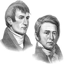
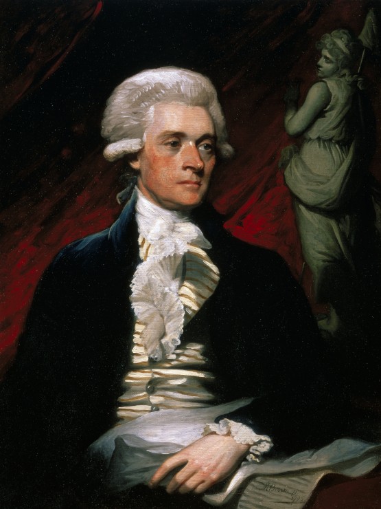
Through it all, the origin for Kansas City’s status as a Crossroads? I would say, that was never Union Station. It was not the nearly-200 trains which pulled into Kansas City each day. It was not the American GI’s who arrived in Kansas City during the War. The origin for Kansas City’s status as Crossroads? That would be one United States President. The origin for Kansas City’s status as Crossroads would be, in my humble opinion, Thomas Jefferson.
In 1803, the size of the United States doubled. The doubling in size of the United States in 1803 was the result of one $15,000,000 real estate deal. That real estate deal being the Louisiana Purchase.
The Louisiana Purchase added 828,000 square miles to the footprint of the United States. And, once the Louisiana Purchase was enacted, Kansas City’s location went from perfect, to PERFECT.
One year after the Louisiana Purchase, President Thomas Jefferson tapped an old wartime buddy of his. That buddy? Meriweather Lewis. Jefferson’s idea? For Meriweather Lewis to lead an expedition west. For Lewis to explore this vast new territory acquired by the United States through the Louisiana Purchase.
Meriweather Lewis added William Clark to this planned expedition. Six weeks after the Jefferson-directed expedition began, Lewis and Clark arrived at a confluence of two important rivers. The Missouri River. The Kansas River.
Or, as we now know this area to be, six weeks after Lewis and Clark ventured out with 3 boats – and a team of 50 – Lewis and Clark arrived at Crossroads. Lewis and Clark arrived in, what would go on to become…Kansas City.
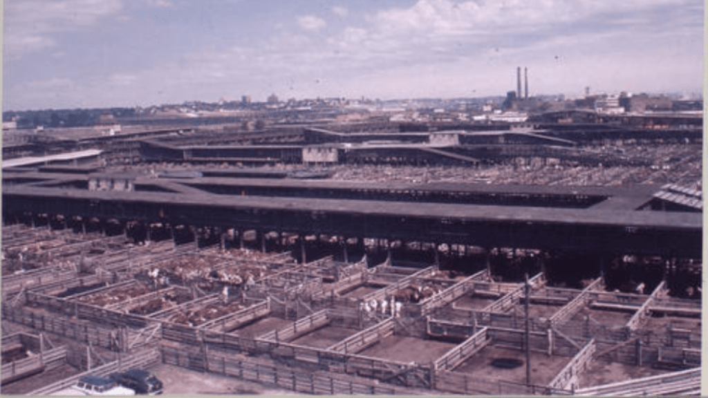
Kansas City’s stockyards – and the KC cattle business – once dominated a section of Kansas City, Missouri known as the West Bottoms.
The cattle industry had been Kansas City’s first multi-million dollar business. Actually, at one time, Kansas City’s stockyards were a multi-million dollar a day business. At their peak, Kansas City’s stockyards were the second busiest stockyards in the United States. Surpassed only by Chicago’s stockyards.
Long before trains transported cattle to and from the Kansas City stockyards, Kansas City’s West Bottoms were known as the French Bottoms. A place where French trappers and native Americans partook in commerce.
The Santa Fe Trail. Trade with Mexico. Western immigration routes. Steamships transporting goods along the Missouri River… At one time, one way or another, each converged in Kansas City’s West Bottoms. And in a country eager to expand its footprint to the West, Kansas City’s West Bottoms was the hub. As Kansas City became known as “the Gateway to the Southwest.”
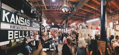
In the early Twentieth Century, Kansas City executives oversaw livestock businesses from offices located in the West Bottoms. Today, many of those old offices are lofts. The West Bottoms has become a trendy destination…sought after by young urban professionals. That office space which was once been used by cattle executives? It now houses budding Kansas City entrepreneurs.
There is still manufacturing in the West Bottoms. There are still warehouses. Today, a West Bottoms manufacturing facility – or a West Bottoms warehouse -might just be located on the same block as a restaurant or a haunted house. Near The Beast. Or The Edge of Hell. Or The Chambers of Edgar Allan Poe…
In 1923, the West Bottoms received 3,500,000 hogs, 350,000 calves, 1,000,000 sheep, plus 40,000 horses. That same year, Kansas City’s stockyards set the world record for one day’s receipt of cattle: 60,206 head.
One hundred years later? No cattle.
The live cattle price of $2.88 USD per pound and the lean hog price of $.83 USD per pound? Not too relevant in the West Bottoms in 2024.
High-speed Internet connection? Great restaurants? Those are relevant.
Freight trains still roll through Kansas City’s West Bottoms. Often, transporting millions of gallons of Bakken crude. Railroad tracks run straight through the middle of the West Bottoms. Train engine horns still blare…everyday. At its peak, 16 railroads once converged in the West Bottoms.